
Geography / 10 questions
North America map quiz
Find countries, follow the isthmus, and explore Caribbean islands.
About 3–5 minutes · No timer
10 random questions per round · 50 questions in the full bank below
Published by Quizpen · Explanations include linked supporting reading. See our source-checking process and review limits.
Getting your round ready…
BEHIND THE ROUND
A little more about this quiz
North America is more than Canada, the United States, and Mexico. This map quiz also follows the Central American isthmus and the Caribbean island chains. Locate all 23 sovereign countries, then test coastal directions, neighboring countries, island groups, and the difference between a sovereign country and a territory.
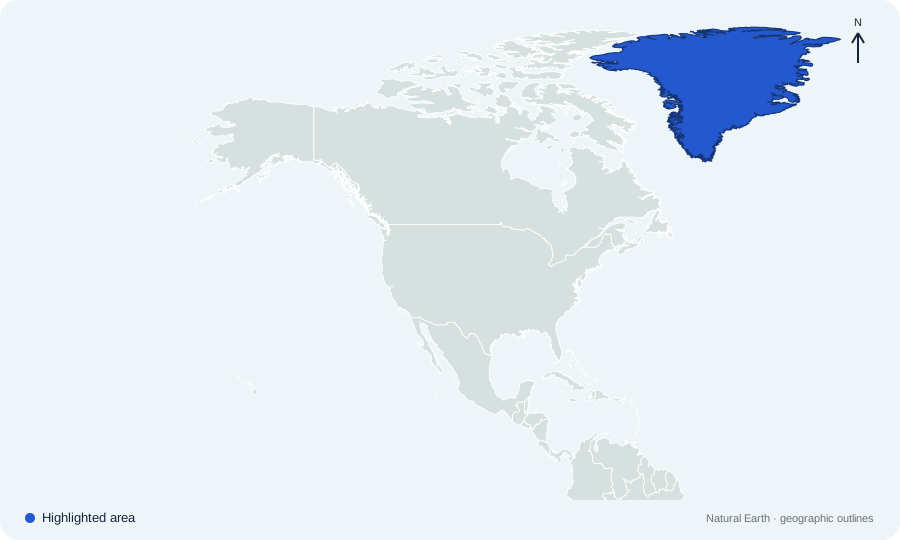
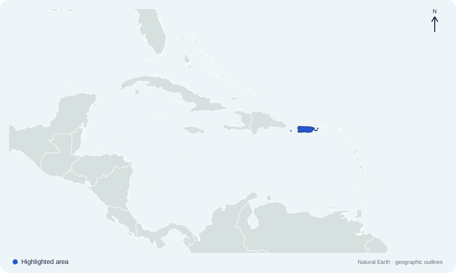
Central America and the Caribbean have their own closer views, and small targets include an enlarged outline. Ten questions are selected from a bank of fifty for each round. Greenland and Puerto Rico appear in questions that state their political status explicitly, so geographic location does not get confused with sovereignty.
LEARN THE PATTERN
Learn North America by mainland, isthmus, and islands
Use the regional views to practice one group at a time, then connect a country’s outline with its neighbors and political status.
All 23 North American sovereign countries in three study groups
This quiz uses a broad geographic North America that includes Central America and the Caribbean. Learn the 3 + 7 + 13 groups, then locate each country on the numbered maps.
| Study group | Countries in this quiz | Count |
|---|---|---|
| Canada, the United States, and Mexico | Canada; United States; Mexico | 3 |
| Central American isthmus | Belize; Guatemala; El Salvador; Honduras; Nicaragua; Costa Rica; Panama | 7 |
| Caribbean country set | Antigua and Barbuda; The Bahamas; Barbados; Cuba; Dominica; Dominican Republic; Grenada; Haiti; Jamaica; Saint Kitts and Nevis; Saint Lucia; Saint Vincent and the Grenadines; Trinidad and Tobago | 13 |
These are learning groups, not an exact copy of the UN statistical subregions. The Bahamas is included in the Caribbean country set although its islands lie in the Atlantic. Territories are not counted among the 23 sovereign countries.
Reference sources: UN Statistics: countries, areas, and regional groupings · OAS: country and capital directory · Nordic cooperation: Greenland’s geography and status · US Interior: territory definitions
Check what you remember
Look away from the table. Try each question, then open it to check your answer.
Which seven sovereign countries are on the Guatemala-to-Panama isthmus?Show answer
Belize, Guatemala, El Salvador, Honduras, Nicaragua, Costa Rica, and Panama. Use the close-up maps to separate the two countries north of Honduras from the chain continuing toward Panama.
Are Dominica and the Dominican Republic the same country?Show answer
No. Dominica is a separate island country. The Dominican Republic shares Hispaniola with Haiti.
Why do Greenland and Puerto Rico not add two more sovereign countries to the total?Show answer
Greenland is an autonomous part of the Kingdom of Denmark. Puerto Rico is a territory of the United States. The bank asks about their status separately.
Start with large mainland anchors
Locate Canada, the United States, and Mexico before working south along the Central American isthmus. In questions about Alaska, remember that Canada separates it from the forty-eight contiguous US states. Read the direction in the prompt before choosing a neighbor.
Zoom in on island countries
Small island targets use closer views and an enlarged outline. Locate Cuba first, then compare Jamaica, The Bahamas, and the two countries sharing Hispaniola. Dominica and the Dominican Republic are different countries; the similar names do not identify the same island.
Separate location from sovereignty
Greenland and Puerto Rico belong on a geographic map without becoming additional sovereign-country answers. First identify the highlighted place, then answer the exact question about country, territory, island, or sea. Cover the choices in the full bank and describe one map clue before revealing an answer.
Put it into practice
Further reading: UN Statistics: countries, areas, and regional groupings · OAS: country and capital directory · Nordic cooperation: Greenland’s geography and status · US Interior: territory definitions
QUESTIONS & ANSWERS
North America map quiz: the full question sheet
Locate countries across Northern America, Central America, and the Caribbean. Ten random questions draw from 50 map and geography challenges.
By Quizpen · Updated
Browse the full question bank50 questions & answers
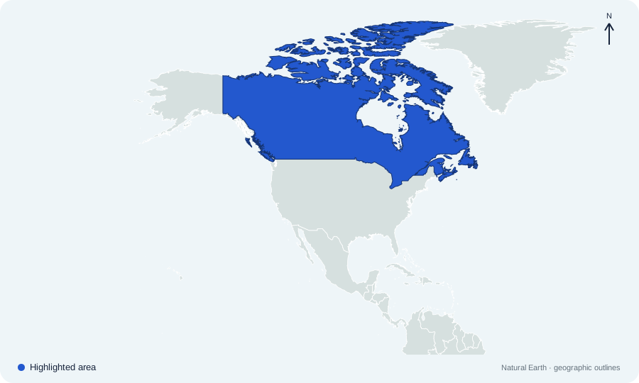
Which sovereign country is highlighted on North America map 01?
 Open map at full size ↗
Image source & credit
Map outlines: Natural Earth; quiz rendering: Quizpen. Source ↗ · Public domain geographic data. Resized for display.
Reveal answer
Canada. Canada occupies the northern part of the continent, stretching from the Pacific to the Atlantic and Arctic oceans.
Sources for this answer
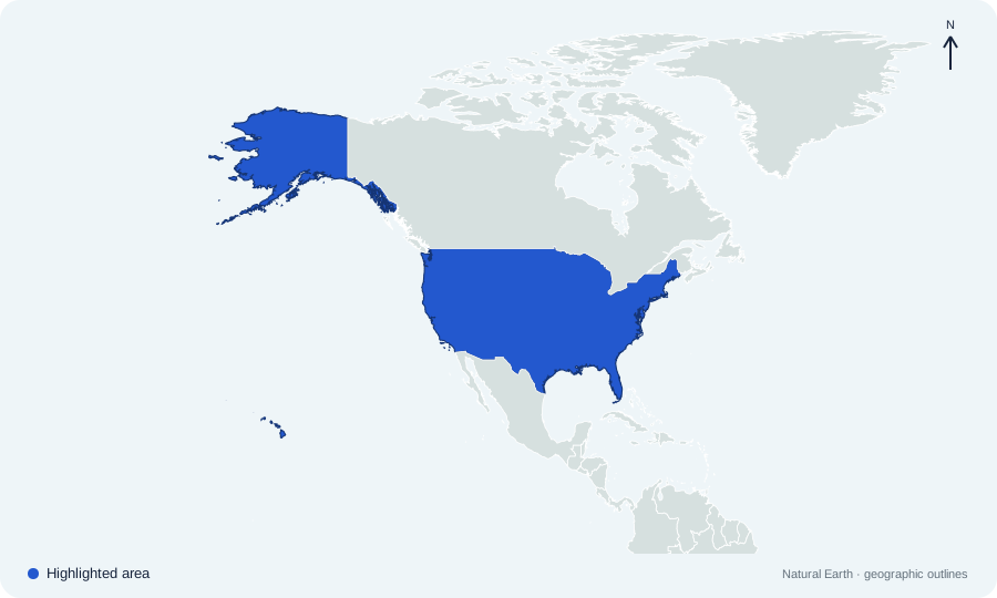
Which sovereign country is highlighted on North America map 02?
 Open map at full size ↗
Image source & credit
Map outlines: Natural Earth; quiz rendering: Quizpen. Source ↗ · Public domain geographic data. Resized for display.
Reveal answer
United States. The United States lies south of Canada; Alaska is its separate northwestern state. The view focuses on North America.
Sources for this answer
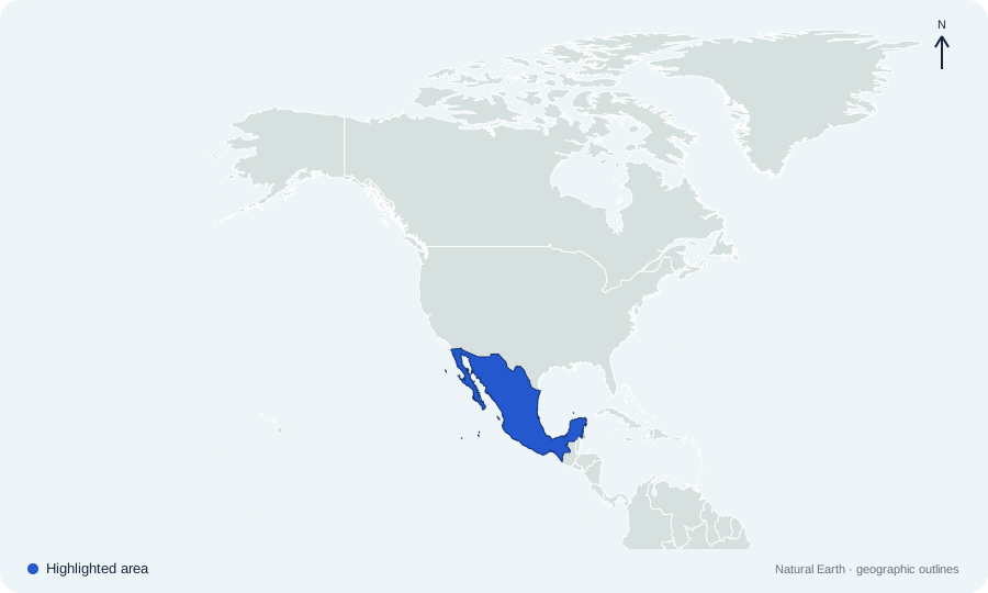
Which sovereign country is highlighted on North America map 03?
 Open map at full size ↗
Image source & credit
Map outlines: Natural Earth; quiz rendering: Quizpen. Source ↗ · Public domain geographic data. Resized for display.
Reveal answer
Mexico. Mexico lies south of the United States and north of Guatemala and Belize.
Sources for this answer
Which sovereign country is highlighted on North America map 04?
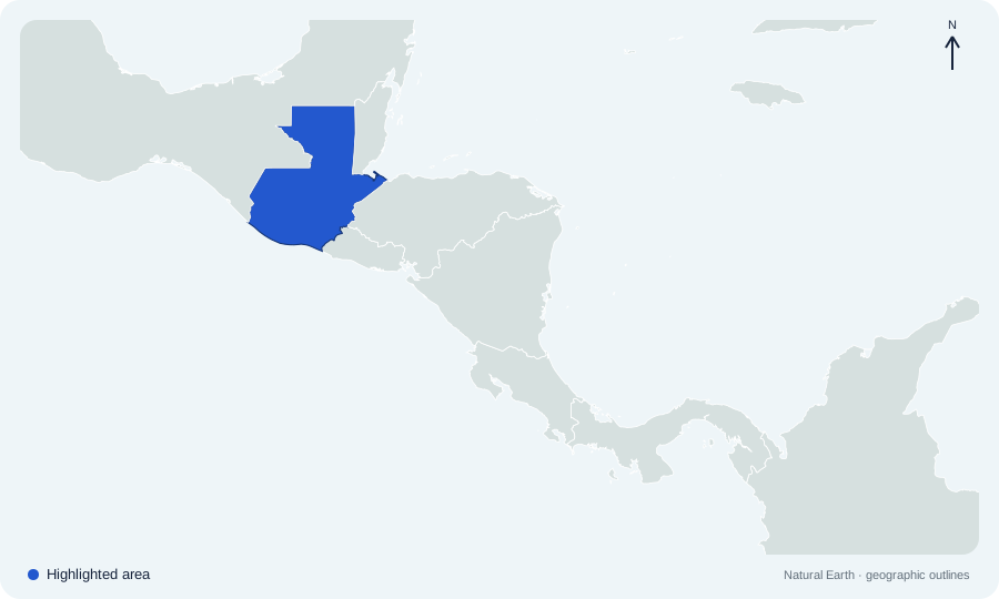 Open map at full size ↗
Image source & credit
Map outlines: Natural Earth; quiz rendering: Quizpen. Source ↗ · Public domain geographic data. Resized for display.
Reveal answer
Guatemala. Guatemala lies south of Mexico, with Belize to its northeast and Honduras and El Salvador to its southeast.
Sources for this answer
Which sovereign country is highlighted on North America map 05?
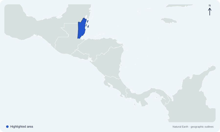 Open map at full size ↗
Image source & credit
Map outlines: Natural Earth; quiz rendering: Quizpen. Source ↗ · Public domain geographic data. Resized for display.
Reveal answer
Belize. Belize lies on the Caribbean coast, east of Guatemala and south of Mexico.
Sources for this answer
Which sovereign country is highlighted on North America map 06?
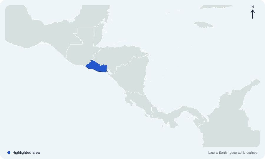 Open map at full size ↗
Image source & credit
Map outlines: Natural Earth; quiz rendering: Quizpen. Source ↗ · Public domain geographic data. Resized for display.
Reveal answer
El Salvador. El Salvador is the small Pacific-facing country between Guatemala and Honduras.
Sources for this answer
Which sovereign country is highlighted on North America map 07?
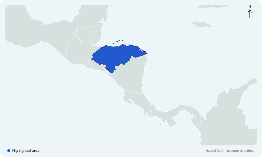 Open map at full size ↗
Image source & credit
Map outlines: Natural Earth; quiz rendering: Quizpen. Source ↗ · Public domain geographic data. Resized for display.
Reveal answer
Honduras. Honduras lies between Guatemala, El Salvador, and Nicaragua, with a long northern Caribbean coast.
Sources for this answer
Which sovereign country is highlighted on North America map 08?
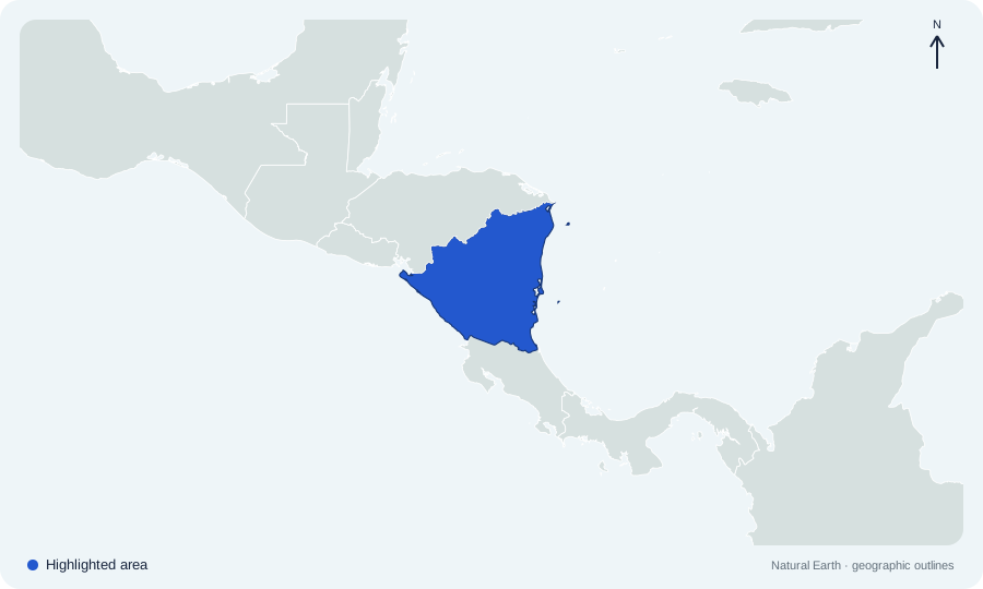 Open map at full size ↗
Image source & credit
Map outlines: Natural Earth; quiz rendering: Quizpen. Source ↗ · Public domain geographic data. Resized for display.
Reveal answer
Nicaragua. Nicaragua lies between Honduras to the north and Costa Rica to the south.
Sources for this answer
Which sovereign country is highlighted on North America map 09?
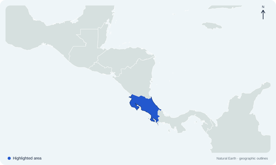 Open map at full size ↗
Image source & credit
Map outlines: Natural Earth; quiz rendering: Quizpen. Source ↗ · Public domain geographic data. Resized for display.
Reveal answer
Costa Rica. Costa Rica occupies the narrow isthmus between Nicaragua and Panama.
Sources for this answer
Which sovereign country is highlighted on North America map 10?
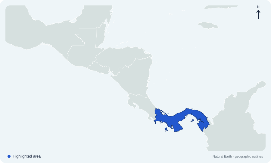 Open map at full size ↗
Image source & credit
Map outlines: Natural Earth; quiz rendering: Quizpen. Source ↗ · Public domain geographic data. Resized for display.
Reveal answer
Panama. Panama connects the rest of Central America with Colombia in South America.
Sources for this answer
Which sovereign country is highlighted on North America map 11?
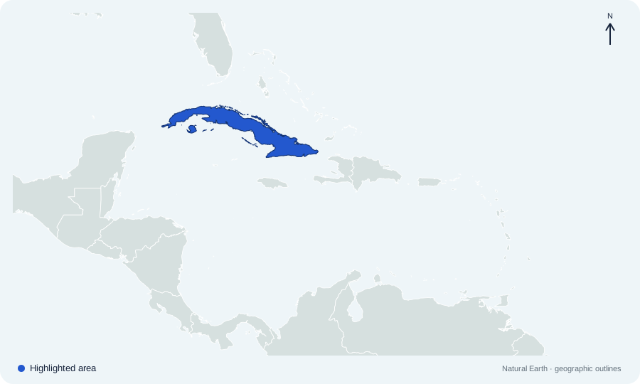 Open map at full size ↗
Image source & credit
Map outlines: Natural Earth; quiz rendering: Quizpen. Source ↗ · Public domain geographic data. Resized for display.
Reveal answer
Cuba. Cuba is the long island south of Florida and north of Jamaica.
Sources for this answer
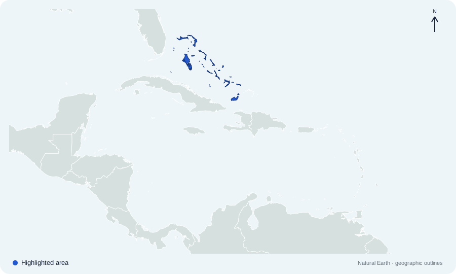
Which sovereign country is highlighted on North America map 12?
 Open map at full size ↗
Image source & credit
Map outlines: Natural Earth; quiz rendering: Quizpen. Source ↗ · Public domain geographic data. Resized for display.
Reveal answer
The Bahamas. The Bahamas form an Atlantic archipelago north of Cuba and southeast of Florida.
Sources for this answer
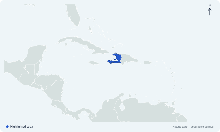
Which sovereign country is highlighted on North America map 13?
 Open map at full size ↗
Image source & credit
Map outlines: Natural Earth; quiz rendering: Quizpen. Source ↗ · Public domain geographic data. Resized for display.
Reveal answer
Haiti. Haiti occupies the western part of Hispaniola; the Dominican Republic occupies the east.
Sources for this answer
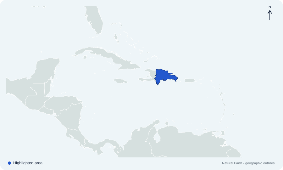
Which sovereign country is highlighted on North America map 14?
 Open map at full size ↗
Image source & credit
Map outlines: Natural Earth; quiz rendering: Quizpen. Source ↗ · Public domain geographic data. Resized for display.
Reveal answer
Dominican Republic. The Dominican Republic occupies the eastern part of Hispaniola, sharing the island with Haiti.
Sources for this answer
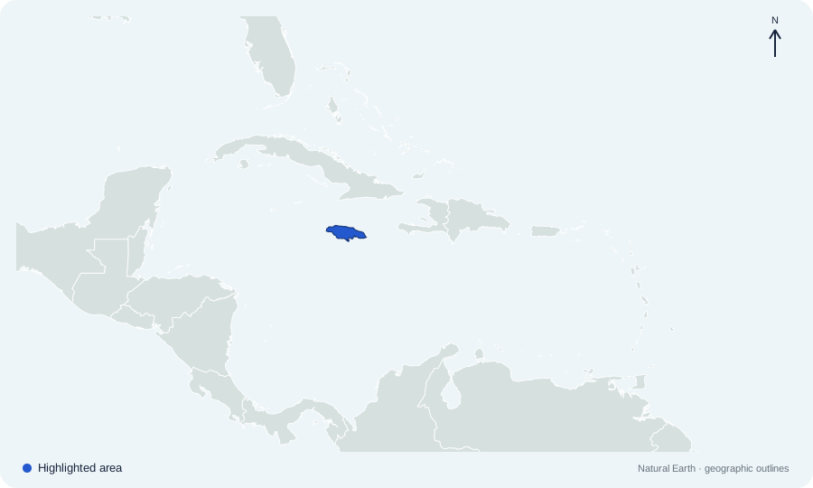
Which sovereign country is highlighted on North America map 15?
 Open map at full size ↗
Image source & credit
Map outlines: Natural Earth; quiz rendering: Quizpen. Source ↗ · Public domain geographic data. Resized for display.
Reveal answer
Jamaica. Jamaica is the island south of Cuba and west of Hispaniola.
Sources for this answer
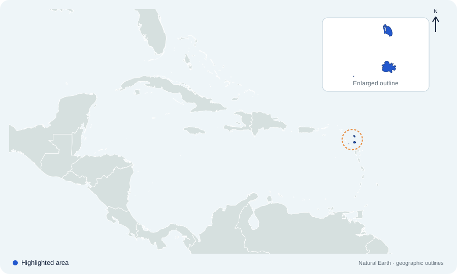
Which sovereign country is highlighted on North America map 16?
 Open map at full size ↗
Image source & credit
Map outlines: Natural Earth; quiz rendering: Quizpen. Source ↗ · Public domain geographic data. Resized for display.
Reveal answer
Antigua and Barbuda. Antigua and Barbuda is a sovereign island country in the northern Lesser Antilles.
Sources for this answer
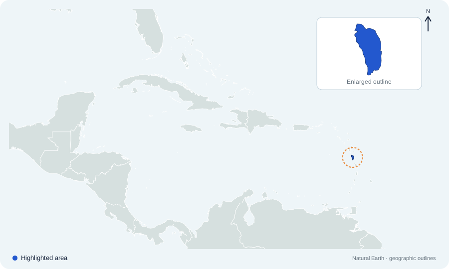
Which sovereign country is highlighted on North America map 17?
 Open map at full size ↗
Image source & credit
Map outlines: Natural Earth; quiz rendering: Quizpen. Source ↗ · Public domain geographic data. Resized for display.
Reveal answer
Dominica. Dominica lies between Guadeloupe and Martinique in the Lesser Antilles. It is separate from the Dominican Republic.
Sources for this answer
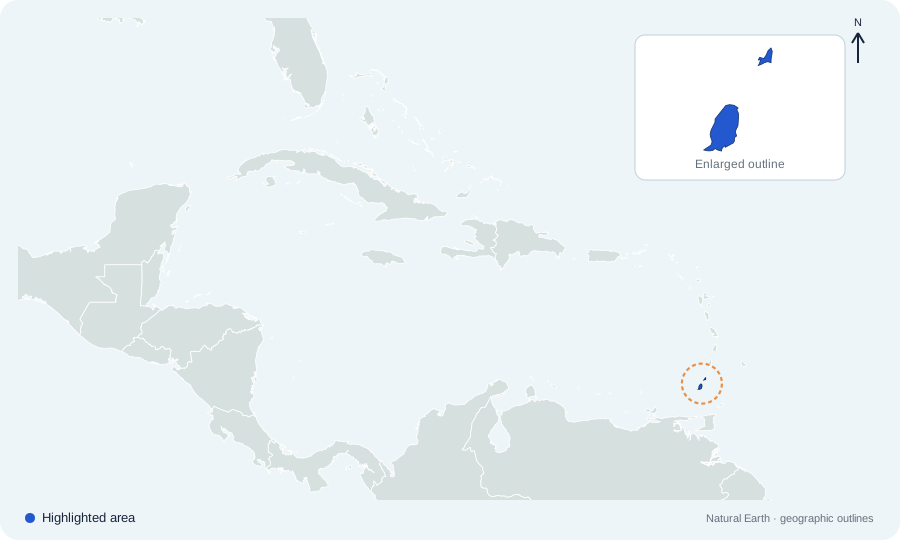
Which sovereign country is highlighted on North America map 18?
 Open map at full size ↗
Image source & credit
Map outlines: Natural Earth; quiz rendering: Quizpen. Source ↗ · Public domain geographic data. Resized for display.
Reveal answer
Grenada. Grenada lies near the southern end of the Lesser Antilles, north of Trinidad and Tobago.
Sources for this answer
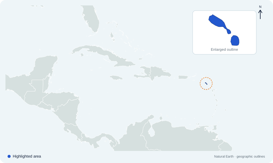
Which sovereign country is highlighted on North America map 19?
 Open map at full size ↗
Image source & credit
Map outlines: Natural Earth; quiz rendering: Quizpen. Source ↗ · Public domain geographic data. Resized for display.
Reveal answer
Saint Kitts and Nevis. Saint Kitts and Nevis is a two-island sovereign federation in the northern Lesser Antilles.
Which sovereign country is highlighted on North America map 20?
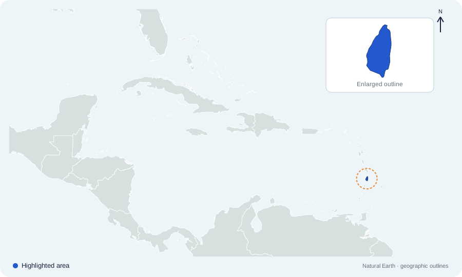 Open map at full size ↗
Image source & credit
Map outlines: Natural Earth; quiz rendering: Quizpen. Source ↗ · Public domain geographic data. Resized for display.
Reveal answer
Saint Lucia. Saint Lucia lies between Martinique to the north and Saint Vincent to the south.
Which sovereign country is highlighted on North America map 21?
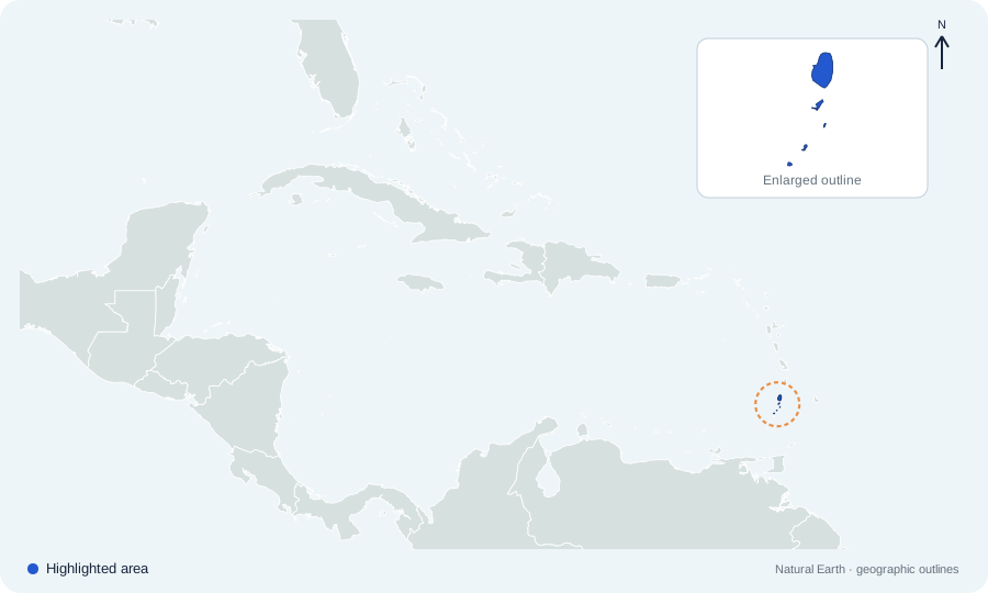 Open map at full size ↗
Image source & credit
Map outlines: Natural Earth; quiz rendering: Quizpen. Source ↗ · Public domain geographic data. Resized for display.
Reveal answer
Saint Vincent and the Grenadines. Saint Vincent and the Grenadines includes the main island of Saint Vincent and smaller islands extending southward.
Which sovereign country is highlighted on North America map 22?
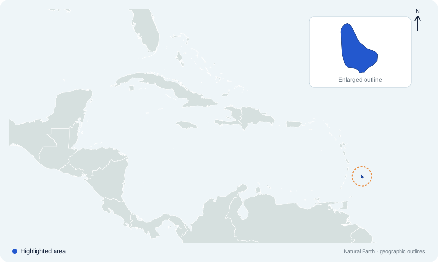 Open map at full size ↗
Image source & credit
Map outlines: Natural Earth; quiz rendering: Quizpen. Source ↗ · Public domain geographic data. Resized for display.
Reveal answer
Barbados. Barbados lies east of the main Windward Islands arc in the Atlantic.
Which sovereign country is highlighted on North America map 23?
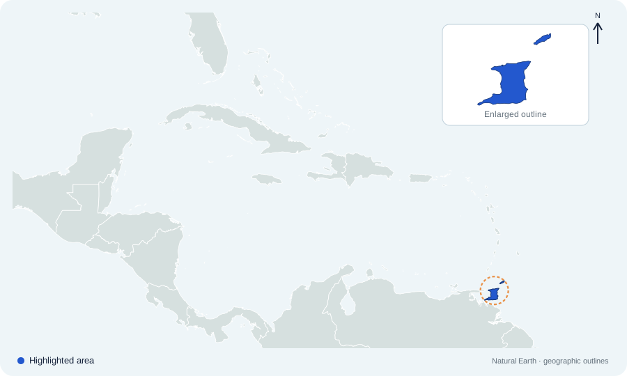 Open map at full size ↗
Image source & credit
Map outlines: Natural Earth; quiz rendering: Quizpen. Source ↗ · Public domain geographic data. Resized for display.
Reveal answer
Trinidad and Tobago. Trinidad and Tobago lies just off the northeastern coast of Venezuela.
What is the political status of highlighted Greenland?
 Open map at full size ↗
Image source & credit
Map outlines: Natural Earth; quiz rendering: Quizpen. Source ↗ · Public domain geographic data. Resized for display.
Reveal answer
An autonomous part of the Kingdom of Denmark. Greenland is geographically in North America and is an autonomous part of the Kingdom of Denmark. It is not a sovereign country.
Sources for this answer
Highlighted Puerto Rico is a territory of which country?
 Open map at full size ↗
Image source & credit
Map outlines: Natural Earth; quiz rendering: Quizpen. Source ↗ · Public domain geographic data. Resized for display.
Reveal answer
United States. Puerto Rico is a US territory in the Caribbean, not one of North America’s sovereign states.
Sources for this answer
Haiti and its eastern neighbor share which island?
Open map at full size ↗Image source & credit
Map outlines: Natural Earth; quiz rendering: Quizpen. Source ↗ · Public domain geographic data. Resized for display.
Reveal answer
Hispaniola. Haiti and the Dominican Republic divide Hispaniola; Haiti occupies the western portion.
Sources for this answer
Which South American country borders highlighted Panama?
Open map at full size ↗Image source & credit
Map outlines: Natural Earth; quiz rendering: Quizpen. Source ↗ · Public domain geographic data. Resized for display.
Reveal answer
Colombia. Panama meets Colombia at the southern end of the Central American isthmus.
Sources for this answer
Which strait separates Alaska from Russia?
Open map at full size ↗Image source & credit
Map outlines: Natural Earth; quiz rendering: Quizpen. Source ↗ · Public domain geographic data. Resized for display.
Reveal answer
Bering Strait. The Bering Strait lies between Alaska and Russia’s Chukotka Peninsula.
Sources for this answer
The Yucatán Peninsula projects from which part of highlighted Mexico?
Open map at full size ↗Image source & credit
Map outlines: Natural Earth; quiz rendering: Quizpen. Source ↗ · Public domain geographic data. Resized for display.
Reveal answer
The southeast. The Yucatán projects northeastward from southeastern Mexico between the Gulf of Mexico and Caribbean Sea; the wider peninsula also includes Belize and Guatemala.
Sources for this answer
The long narrow peninsula on Mexico’s Pacific side is called what?
Open map at full size ↗Image source & credit
Map outlines: Natural Earth; quiz rendering: Quizpen. Source ↗ · Public domain geographic data. Resized for display.
Reveal answer
Baja California. Baja California extends south from northwestern Mexico, separated from the mainland by the Gulf of California.
Which sea touches the coast of highlighted Belize?
Open map at full size ↗Image source & credit
Map outlines: Natural Earth; quiz rendering: Quizpen. Source ↗ · Public domain geographic data. Resized for display.
Reveal answer
Caribbean Sea. Belize has a Caribbean coastline. Its land neighbors are Mexico and Guatemala.
Sources for this answer
Which ocean touches highlighted El Salvador?
Open map at full size ↗Image source & credit
Map outlines: Natural Earth; quiz rendering: Quizpen. Source ↗ · Public domain geographic data. Resized for display.
Reveal answer
Pacific Ocean. El Salvador faces the Pacific and has no Caribbean coastline.
Sources for this answer
Which country lies immediately north of highlighted Nicaragua?
Open map at full size ↗Image source & credit
Map outlines: Natural Earth; quiz rendering: Quizpen. Source ↗ · Public domain geographic data. Resized for display.
Reveal answer
Honduras. Honduras borders Nicaragua to the north; Costa Rica borders it to the south.
Sources for this answer
Which large freshwater lake lies in southwestern highlighted Nicaragua?
Open map at full size ↗Image source & credit
Map outlines: Natural Earth; quiz rendering: Quizpen. Source ↗ · Public domain geographic data. Resized for display.
Reveal answer
Lake Nicaragua. Lake Nicaragua, also called Cocibolca, occupies much of southwestern Nicaragua and contains the island of Ometepe.
Sources for this answer
Which large country borders highlighted Guatemala to the north and west?
Open map at full size ↗Image source & credit
Map outlines: Natural Earth; quiz rendering: Quizpen. Source ↗ · Public domain geographic data. Resized for display.
Reveal answer
Mexico. Guatemala shares its northern and western border with Mexico.
Sources for this answer
The longer northern coast of highlighted Honduras faces which sea?
Open map at full size ↗Image source & credit
Map outlines: Natural Earth; quiz rendering: Quizpen. Source ↗ · Public domain geographic data. Resized for display.
Reveal answer
Caribbean Sea. Honduras has an extensive Caribbean coast and a much shorter Pacific outlet on the Gulf of Fonseca.
Sources for this answer
Which pair of countries borders highlighted Costa Rica?
Open map at full size ↗Image source & credit
Map outlines: Natural Earth; quiz rendering: Quizpen. Source ↗ · Public domain geographic data. Resized for display.
Reveal answer
Nicaragua and Panama. Nicaragua borders Costa Rica to the north and Panama borders it to the southeast.
Sources for this answer
Which highlighted country occupies the largest island in the Caribbean?
Open map at full size ↗Image source & credit
Map outlines: Natural Earth; quiz rendering: Quizpen. Source ↗ · Public domain geographic data. Resized for display.
Reveal answer
Cuba. Cuba is the largest Caribbean island; its long shape extends between the Gulf of Mexico, Atlantic, and Caribbean.
Highlighted Bahamian islands lie mainly in which body of water?
Open map at full size ↗Image source & credit
Map outlines: Natural Earth; quiz rendering: Quizpen. Source ↗ · Public domain geographic data. Resized for display.
Reveal answer
Atlantic Ocean. The Bahamas are in the Atlantic, although they are grouped with the Caribbean region culturally and statistically.
Highlighted Jamaica lies in which direction from Cuba?
Open map at full size ↗Image source & credit
Map outlines: Natural Earth; quiz rendering: Quizpen. Source ↗ · Public domain geographic data. Resized for display.
Reveal answer
South. Jamaica is south of Cuba in the Caribbean Sea.
Sources for this answer
Which statement correctly distinguishes highlighted Dominica from the Dominican Republic?
Open map at full size ↗Image source & credit
Map outlines: Natural Earth; quiz rendering: Quizpen. Source ↗ · Public domain geographic data. Resized for display.
Reveal answer
They are two different sovereign countries. Dominica is an island country in the Lesser Antilles. The Dominican Republic occupies eastern Hispaniola.
Sources for this answer
Highlighted Trinidad and Tobago lies closest to which mainland country?
Open map at full size ↗Image source & credit
Map outlines: Natural Earth; quiz rendering: Quizpen. Source ↗ · Public domain geographic data. Resized for display.
Reveal answer
Venezuela. Trinidad is just off Venezuela’s northeastern coast, well south of most Caribbean islands.
Where is highlighted Barbados relative to the main Windward Islands chain?
Open map at full size ↗Image source & credit
Map outlines: Natural Earth; quiz rendering: Quizpen. Source ↗ · Public domain geographic data. Resized for display.
Reveal answer
To the east. Barbados lies east of the main Windward Islands arc rather than directly on that arc.
Which island is the northern of the two main islands of Antigua and Barbuda?
Open map at full size ↗Image source & credit
Map outlines: Natural Earth; quiz rendering: Quizpen. Source ↗ · Public domain geographic data. Resized for display.
Reveal answer
Barbuda. Barbuda lies north of Antigua; together they give the sovereign country its name.
Sources for this answer
Which island lies southeast of Saint Kitts in the highlighted federation?
Open map at full size ↗Image source & credit
Map outlines: Natural Earth; quiz rendering: Quizpen. Source ↗ · Public domain geographic data. Resized for display.
Reveal answer
Nevis. Nevis lies immediately southeast of Saint Kitts, separated by a narrow channel.
Highlighted Grenada lies south of which country’s main island?
Open map at full size ↗Image source & credit
Map outlines: Natural Earth; quiz rendering: Quizpen. Source ↗ · Public domain geographic data. Resized for display.
Reveal answer
Saint Vincent and the Grenadines. Grenada is south of Saint Vincent and the Grenadines and north of Trinidad and Tobago.
Which island lies directly north of highlighted Saint Lucia?
Open map at full size ↗Image source & credit
Map outlines: Natural Earth; quiz rendering: Quizpen. Source ↗ · Public domain geographic data. Resized for display.
Reveal answer
Martinique. Martinique lies north of Saint Lucia; Saint Vincent lies to its south.
The smaller islands of Saint Vincent and the Grenadines extend mainly which way from Saint Vincent?
Open map at full size ↗Image source & credit
Map outlines: Natural Earth; quiz rendering: Quizpen. Source ↗ · Public domain geographic data. Resized for display.
Reveal answer
South. The Grenadines trail south from Saint Vincent toward Grenada.
Which three oceans border highlighted Canada?
Open map at full size ↗Image source & credit
Map outlines: Natural Earth; quiz rendering: Quizpen. Source ↗ · Public domain geographic data. Resized for display.
Reveal answer
Atlantic, Pacific, and Arctic. Canada has Atlantic, Pacific, and Arctic coastlines, reflecting its northern position and great east–west extent.
Which country separates Alaska from the 48 contiguous US states?
Open map at full size ↗Image source & credit
Map outlines: Natural Earth; quiz rendering: Quizpen. Source ↗ · Public domain geographic data. Resized for display.
Reveal answer
Canada. Canada lies between Alaska and the contiguous United States. Alaska remains a US state.
Sources for this answer
Answer key
- Canada. Canada occupies the northern part of the continent, stretching from the Pacific to the Atlantic and Arctic oceans.
- United States. The United States lies south of Canada; Alaska is its separate northwestern state. The view focuses on North America.
- Mexico. Mexico lies south of the United States and north of Guatemala and Belize.
- Guatemala. Guatemala lies south of Mexico, with Belize to its northeast and Honduras and El Salvador to its southeast.
- Belize. Belize lies on the Caribbean coast, east of Guatemala and south of Mexico.
- El Salvador. El Salvador is the small Pacific-facing country between Guatemala and Honduras.
- Honduras. Honduras lies between Guatemala, El Salvador, and Nicaragua, with a long northern Caribbean coast.
- Nicaragua. Nicaragua lies between Honduras to the north and Costa Rica to the south.
- Costa Rica. Costa Rica occupies the narrow isthmus between Nicaragua and Panama.
- Panama. Panama connects the rest of Central America with Colombia in South America.
- Cuba. Cuba is the long island south of Florida and north of Jamaica.
- The Bahamas. The Bahamas form an Atlantic archipelago north of Cuba and southeast of Florida.
- Haiti. Haiti occupies the western part of Hispaniola; the Dominican Republic occupies the east.
- Dominican Republic. The Dominican Republic occupies the eastern part of Hispaniola, sharing the island with Haiti.
- Jamaica. Jamaica is the island south of Cuba and west of Hispaniola.
- Antigua and Barbuda. Antigua and Barbuda is a sovereign island country in the northern Lesser Antilles.
- Dominica. Dominica lies between Guadeloupe and Martinique in the Lesser Antilles. It is separate from the Dominican Republic.
- Grenada. Grenada lies near the southern end of the Lesser Antilles, north of Trinidad and Tobago.
- Saint Kitts and Nevis. Saint Kitts and Nevis is a two-island sovereign federation in the northern Lesser Antilles.
- Saint Lucia. Saint Lucia lies between Martinique to the north and Saint Vincent to the south.
- Saint Vincent and the Grenadines. Saint Vincent and the Grenadines includes the main island of Saint Vincent and smaller islands extending southward.
- Barbados. Barbados lies east of the main Windward Islands arc in the Atlantic.
- Trinidad and Tobago. Trinidad and Tobago lies just off the northeastern coast of Venezuela.
- An autonomous part of the Kingdom of Denmark. Greenland is geographically in North America and is an autonomous part of the Kingdom of Denmark. It is not a sovereign country.
- United States. Puerto Rico is a US territory in the Caribbean, not one of North America’s sovereign states.
- Hispaniola. Haiti and the Dominican Republic divide Hispaniola; Haiti occupies the western portion.
- Colombia. Panama meets Colombia at the southern end of the Central American isthmus.
- Bering Strait. The Bering Strait lies between Alaska and Russia’s Chukotka Peninsula.
- The southeast. The Yucatán projects northeastward from southeastern Mexico between the Gulf of Mexico and Caribbean Sea; the wider peninsula also includes Belize and Guatemala.
- Baja California. Baja California extends south from northwestern Mexico, separated from the mainland by the Gulf of California.
- Caribbean Sea. Belize has a Caribbean coastline. Its land neighbors are Mexico and Guatemala.
- Pacific Ocean. El Salvador faces the Pacific and has no Caribbean coastline.
- Honduras. Honduras borders Nicaragua to the north; Costa Rica borders it to the south.
- Lake Nicaragua. Lake Nicaragua, also called Cocibolca, occupies much of southwestern Nicaragua and contains the island of Ometepe.
- Mexico. Guatemala shares its northern and western border with Mexico.
- Caribbean Sea. Honduras has an extensive Caribbean coast and a much shorter Pacific outlet on the Gulf of Fonseca.
- Nicaragua and Panama. Nicaragua borders Costa Rica to the north and Panama borders it to the southeast.
- Cuba. Cuba is the largest Caribbean island; its long shape extends between the Gulf of Mexico, Atlantic, and Caribbean.
- Atlantic Ocean. The Bahamas are in the Atlantic, although they are grouped with the Caribbean region culturally and statistically.
- South. Jamaica is south of Cuba in the Caribbean Sea.
- They are two different sovereign countries. Dominica is an island country in the Lesser Antilles. The Dominican Republic occupies eastern Hispaniola.
- Venezuela. Trinidad is just off Venezuela’s northeastern coast, well south of most Caribbean islands.
- To the east. Barbados lies east of the main Windward Islands arc rather than directly on that arc.
- Barbuda. Barbuda lies north of Antigua; together they give the sovereign country its name.
- Nevis. Nevis lies immediately southeast of Saint Kitts, separated by a narrow channel.
- Saint Vincent and the Grenadines. Grenada is south of Saint Vincent and the Grenadines and north of Trinidad and Tobago.
- Martinique. Martinique lies north of Saint Lucia; Saint Vincent lies to its south.
- South. The Grenadines trail south from Saint Vincent toward Grenada.
- Atlantic, Pacific, and Arctic. Canada has Atlantic, Pacific, and Arctic coastlines, reflecting its northern position and great east–west extent.
- Canada. Canada lies between Alaska and the contiguous United States. Alaska remains a US state.