
Geography / 10 questions
Australia map quiz
Locate states, territories, cities, straits, and iconic landscapes.
About 3–5 minutes · No timer
10 random questions per round · 50 questions in the full bank below
Published by Quizpen · Explanations include linked supporting reading. See our source-checking process and review limits.
Getting your round ready…
BEHIND THE ROUND
A little more about this quiz
Start with Australia’s six states, then locate the Northern Territory, the ACT, and the small Jervis Bay Territory. City markers move the challenge from outlines to places: can you distinguish Perth’s west-coast position from Darwin in the north or Alice Springs in the interior?
The fifty-question bank also covers state capitals, the Great Barrier Reef, Bass and Torres straits, Uluru, and major desert regions. Each round selects ten questions. The wording distinguishes states from territories, and point markers indicate approximate locations rather than the full extent of a reef, gulf, or other large feature.
LEARN THE PATTERN
Read Australia’s outlines and point markers
Keep three tasks separate: identify a state or territory, locate a city, and name a landform or body of water.
Australia’s six states and two major mainland territories
Learn each jurisdiction with its capital. The national capital is Canberra; Sydney and Melbourne are state capitals.
| State or territory | Capital | Type |
|---|---|---|
| New South Wales | Sydney | State |
| Victoria | Melbourne | State |
| Queensland | Brisbane | State |
| Western Australia | Perth | State |
| South Australia | Adelaide | State |
| Tasmania | Hobart | State |
| Australian Capital Territory | Canberra | Territory; Canberra is also the national capital |
| Northern Territory | Darwin | Territory |
The eight-row table is a common starting set, not an exhaustive list of Australian territories. The map bank also identifies Jervis Bay Territory, a small separate territory on the New South Wales coast. Point markers show approximate locations, not the full area of a reef, gulf, or landform.
Reference sources: Australian Home Affairs: states, territories, and capitals · Geoscience Australia: reference maps · Australian Government: Jervis Bay Territory
Check what you remember
Look away from the table. Try each question, then open it to check your answer.
What is Australia’s national capital, and in which territory is it located?Show answer
Canberra, in the Australian Capital Territory. Sydney is New South Wales’s capital; Melbourne is Victoria’s capital.
Which capitals belong to Western Australia and the Northern Territory?Show answer
Perth is Western Australia’s capital. Darwin is the Northern Territory’s capital.
Which strait separates Tasmania from the mainland?Show answer
Bass Strait. Torres Strait is farther north, beyond Cape York.
Attach a capital to each jurisdiction
Learn the six state-capital pairs and the ACT–Canberra and Northern Territory–Darwin pairs. Canberra is the national capital; Sydney and Melbourne are state capitals. Jervis Bay Territory is an additional small territory in the map bank, rather than a seventh state.
Use position to identify a city
A city question uses a point marker rather than a highlighted state outline. Compare Perth in the west, Darwin in the north, and Alice Springs in the interior. State the direction or nearby jurisdiction before naming the city, then check the explanation.
Treat landform markers as approximate cues
A single point does not show the entire Great Barrier Reef, gulf, or desert. Read whether a prompt asks for a strait, reef, peninsula, island, or city. Bass Strait separates Tasmania from the mainland; Torres Strait lies north of Cape York. Keep those locations distinct when reviewing the map.
Put it into practice
Further reading: Australian Home Affairs: states, territories, and capitals · Geoscience Australia: reference maps · Australian Government: Jervis Bay Territory
QUESTIONS & ANSWERS
Australia map quiz: the full question sheet
Find Australia’s states, mainland territories, cities, and distinctive physical features. Each round selects ten map questions from a varied bank of 50.
By Quizpen · Updated
Browse the full question bank50 questions & answers
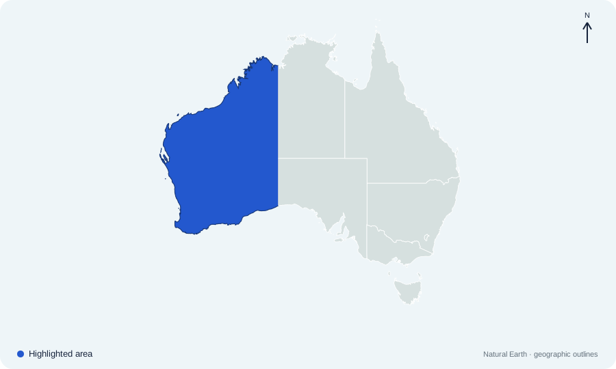
Which Australian state or territory is highlighted on map 01?
 Open map at full size ↗
Image source & credit
Map outlines: Natural Earth; quiz rendering: Quizpen. Source ↗ · Public domain geographic data. Resized for display.
Reveal answer
Western Australia. Western Australia occupies the broad western third of mainland Australia.
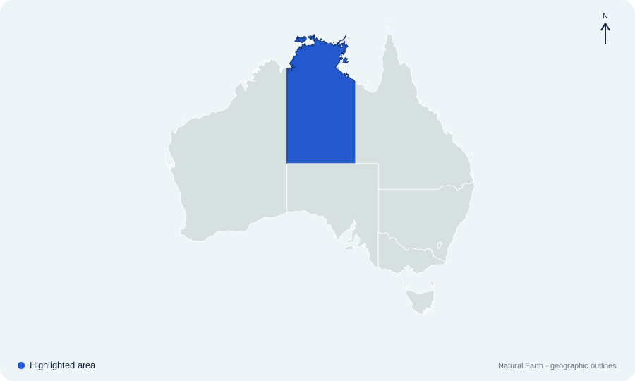
Which Australian state or territory is highlighted on map 02?
 Open map at full size ↗
Image source & credit
Map outlines: Natural Earth; quiz rendering: Quizpen. Source ↗ · Public domain geographic data. Resized for display.
Reveal answer
Northern Territory. The Northern Territory lies in the north-central mainland; it is a territory, not a state.
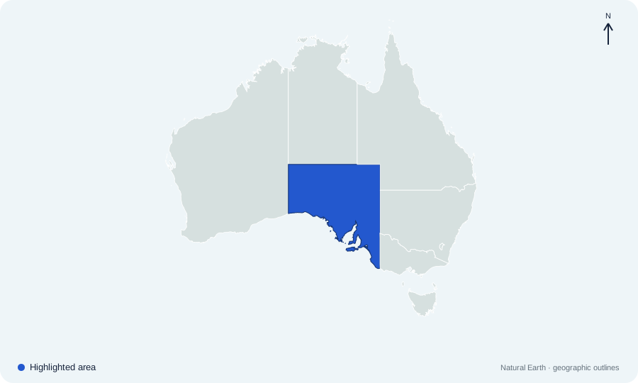
Which Australian state or territory is highlighted on map 03?
 Open map at full size ↗
Image source & credit
Map outlines: Natural Earth; quiz rendering: Quizpen. Source ↗ · Public domain geographic data. Resized for display.
Reveal answer
South Australia. South Australia occupies the central southern mainland.
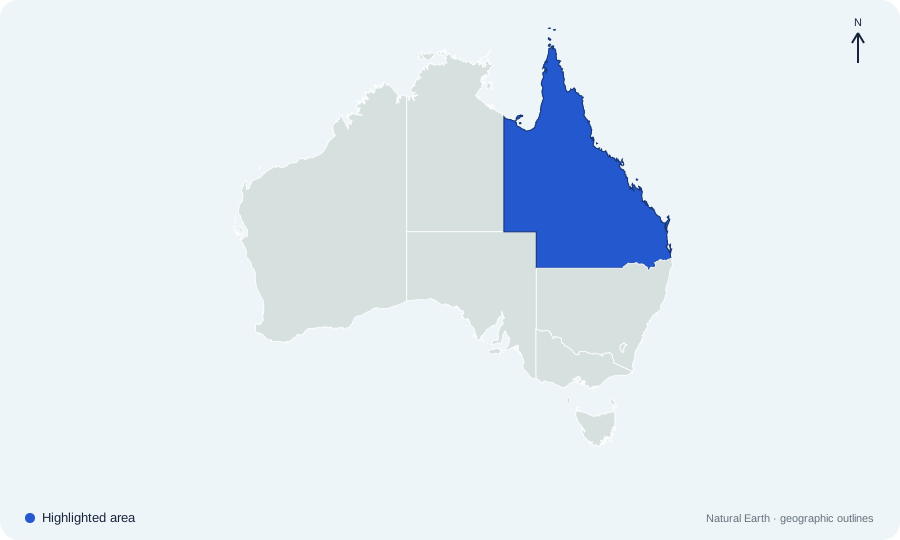
Which Australian state or territory is highlighted on map 04?
 Open map at full size ↗
Image source & credit
Map outlines: Natural Earth; quiz rendering: Quizpen. Source ↗ · Public domain geographic data. Resized for display.
Reveal answer
Queensland. Queensland occupies the northeastern mainland, including Cape York Peninsula.
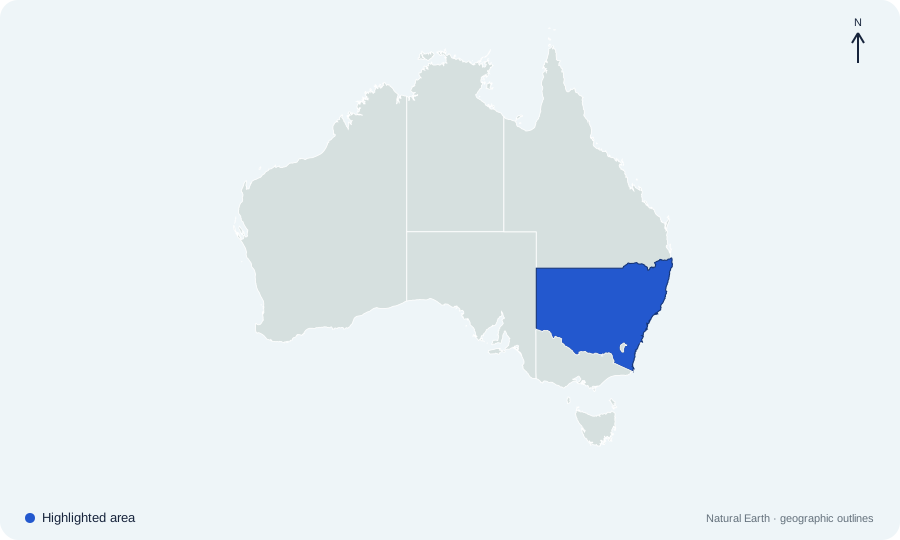
Which Australian state or territory is highlighted on map 05?
 Open map at full size ↗
Image source & credit
Map outlines: Natural Earth; quiz rendering: Quizpen. Source ↗ · Public domain geographic data. Resized for display.
Reveal answer
New South Wales. New South Wales lies on the eastern mainland, north of Victoria.
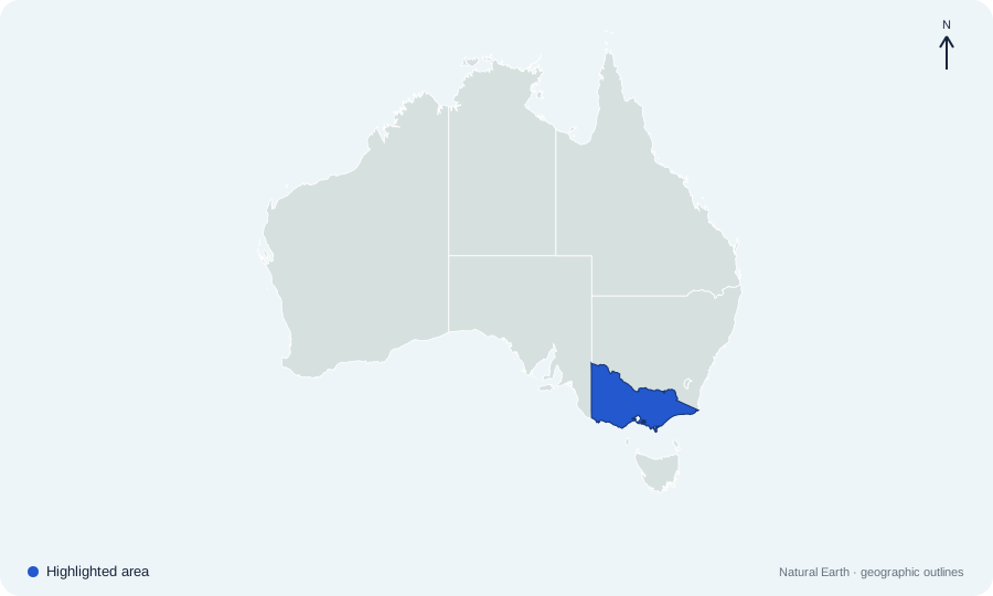
Which Australian state or territory is highlighted on map 06?
 Open map at full size ↗
Image source & credit
Map outlines: Natural Earth; quiz rendering: Quizpen. Source ↗ · Public domain geographic data. Resized for display.
Reveal answer
Victoria. Victoria occupies the southeastern corner of the mainland, south of New South Wales.
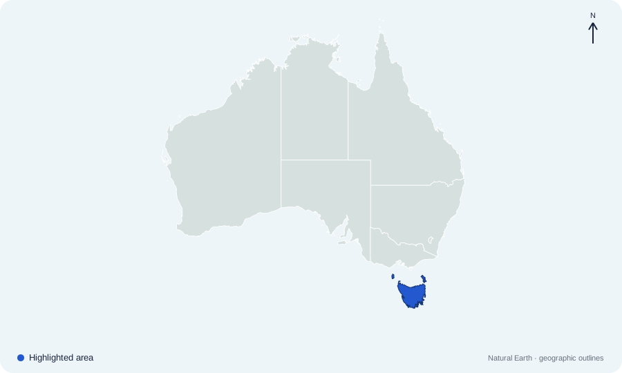
Which Australian state or territory is highlighted on map 07?
 Open map at full size ↗
Image source & credit
Map outlines: Natural Earth; quiz rendering: Quizpen. Source ↗ · Public domain geographic data. Resized for display.
Reveal answer
Tasmania. Tasmania is the island state south of the mainland across Bass Strait.
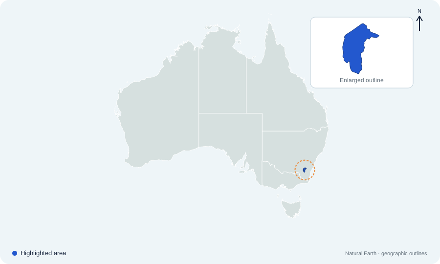
Which Australian state or territory is highlighted on map 08?
 Open map at full size ↗
Image source & credit
Map outlines: Natural Earth; quiz rendering: Quizpen. Source ↗ · Public domain geographic data. Resized for display.
Reveal answer
Australian Capital Territory. The Australian Capital Territory is the small inland territory within New South Wales that contains Canberra.
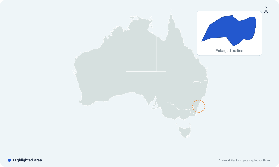
Which Australian state or territory is highlighted on map 09?
 Open map at full size ↗
Image source & credit
Map outlines: Natural Earth; quiz rendering: Quizpen. Source ↗ · Public domain geographic data. Resized for display.
Reveal answer
Jervis Bay Territory. Jervis Bay Territory is a small federal territory on the New South Wales coast. It is distinct from the landlocked ACT.
Sources for this answer
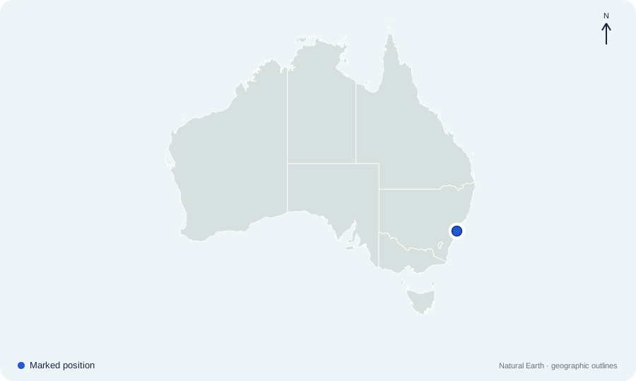
Which city is marked by the dot on Australia city map 01?
 Open map at full size ↗
Image source & credit
Map outlines: Natural Earth; quiz rendering: Quizpen. Source ↗ · Public domain geographic data. Resized for display.
Reveal answer
Sydney. Sydney lies on the New South Wales coast. Its harbor-side position is east of the inland national capital, Canberra.
Sources for this answer
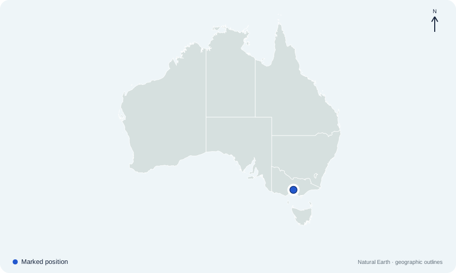
Which city is marked by the dot on Australia city map 02?
 Open map at full size ↗
Image source & credit
Map outlines: Natural Earth; quiz rendering: Quizpen. Source ↗ · Public domain geographic data. Resized for display.
Reveal answer
Melbourne. Melbourne lies in southern Victoria at the head of Port Phillip Bay. Tasmania is farther south, across Bass Strait.
Sources for this answer
Which city is marked by the dot on Australia city map 03?
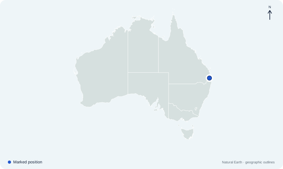 Open map at full size ↗
Image source & credit
Map outlines: Natural Earth; quiz rendering: Quizpen. Source ↗ · Public domain geographic data. Resized for display.
Reveal answer
Brisbane. Brisbane is in southeastern Queensland. It is much farther south than Cairns, even though both cities are in the same state.
Sources for this answer
Which city is marked by the dot on Australia city map 04?
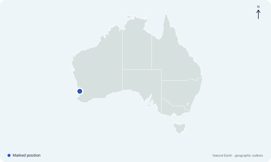 Open map at full size ↗
Image source & credit
Map outlines: Natural Earth; quiz rendering: Quizpen. Source ↗ · Public domain geographic data. Resized for display.
Reveal answer
Perth. Perth is near Western Australia’s southwest coast. Its western position separates it clearly from the cluster of capitals on Australia’s eastern side.
Sources for this answer
Which city is marked by the dot on Australia city map 05?
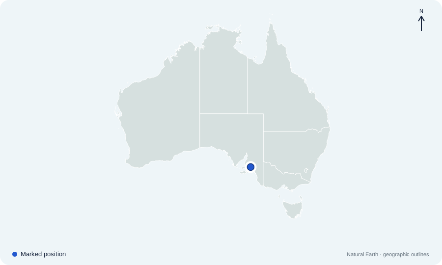 Open map at full size ↗
Image source & credit
Map outlines: Natural Earth; quiz rendering: Quizpen. Source ↗ · Public domain geographic data. Resized for display.
Reveal answer
Adelaide. Adelaide lies beside Gulf St Vincent in South Australia. It is west of Melbourne, near the eastern end of the state’s southern coastline.
Sources for this answer
Which city is marked by the dot on Australia city map 06?
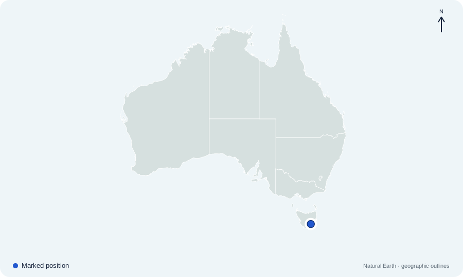 Open map at full size ↗
Image source & credit
Map outlines: Natural Earth; quiz rendering: Quizpen. Source ↗ · Public domain geographic data. Resized for display.
Reveal answer
Hobart. Hobart lies in southeastern Tasmania on the River Derwent. Its island location distinguishes it from the mainland capitals.
Sources for this answer
Which city is marked by the dot on Australia city map 07?
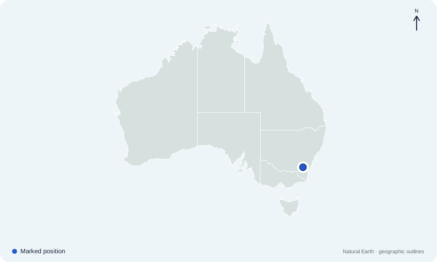 Open map at full size ↗
Image source & credit
Map outlines: Natural Earth; quiz rendering: Quizpen. Source ↗ · Public domain geographic data. Resized for display.
Reveal answer
Canberra. Canberra lies inland in the ACT, within New South Wales. Sydney and Melbourne are separate state capitals, not Australia’s national capital.
Sources for this answer
Which city is marked by the dot on Australia city map 08?
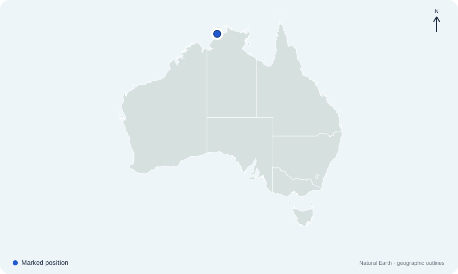 Open map at full size ↗
Image source & credit
Map outlines: Natural Earth; quiz rendering: Quizpen. Source ↗ · Public domain geographic data. Resized for display.
Reveal answer
Darwin. Darwin is on the far northern coast of the Northern Territory. Alice Springs is also in that territory but lies deep in the interior.
Sources for this answer
Which city is marked by the dot on Australia city map 09?
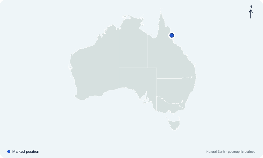 Open map at full size ↗
Image source & credit
Map outlines: Natural Earth; quiz rendering: Quizpen. Source ↗ · Public domain geographic data. Resized for display.
Reveal answer
Cairns. Cairns lies on the coast of far northern Queensland, close to the Great Barrier Reef region. It is well north of Brisbane and the Gold Coast.
Sources for this answer
Which city is marked by the dot on Australia city map 10?
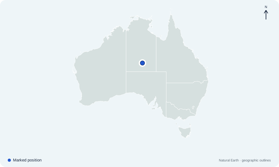 Open map at full size ↗
Image source & credit
Map outlines: Natural Earth; quiz rendering: Quizpen. Source ↗ · Public domain geographic data. Resized for display.
Reveal answer
Alice Springs. Alice Springs lies in the Northern Territory’s central interior. Its inland location distinguishes it from Darwin, the territory’s coastal capital.
Sources for this answer
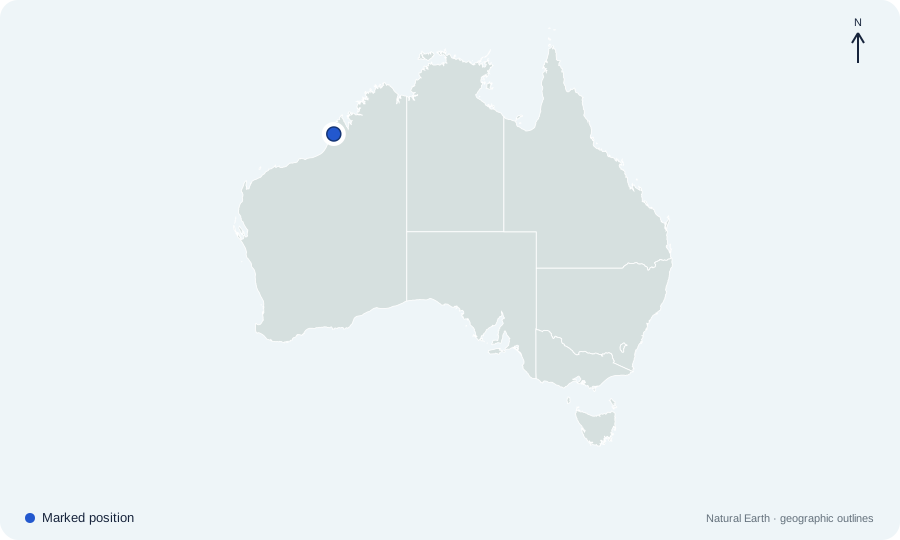
Which city is marked by the dot on Australia city map 11?
 Open map at full size ↗
Image source & credit
Map outlines: Natural Earth; quiz rendering: Quizpen. Source ↗ · Public domain geographic data. Resized for display.
Reveal answer
Broome. Broome is a coastal town in northwestern Western Australia, in the Kimberley region. It lies far north of Perth.
Sources for this answer
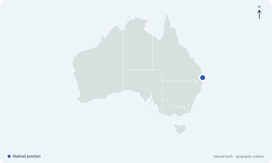
Which city is marked by the dot on Australia city map 12?
 Open map at full size ↗
Image source & credit
Map outlines: Natural Earth; quiz rendering: Quizpen. Source ↗ · Public domain geographic data. Resized for display.
Reveal answer
Gold Coast. The Gold Coast lies on Queensland’s southeastern coast, south of Brisbane and close to the New South Wales border.
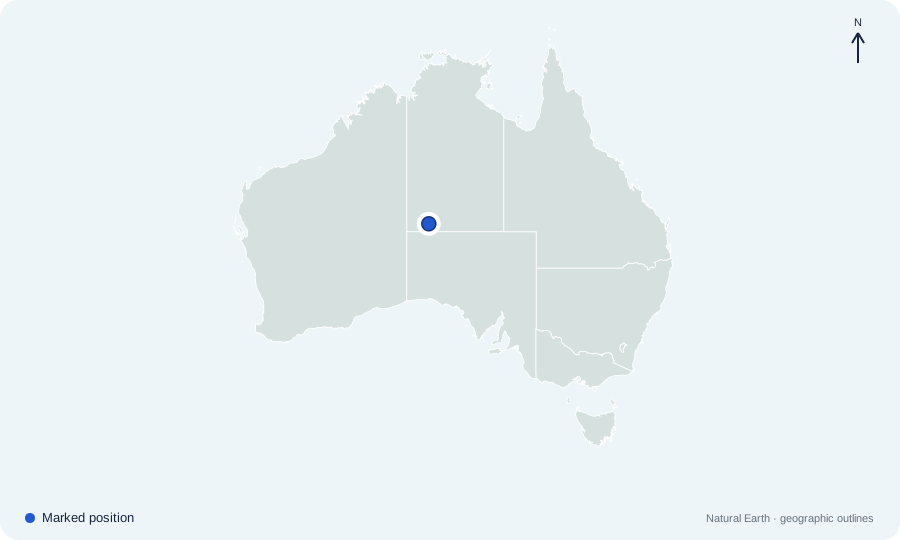
Which landmark is marked in the central Australian interior?
 Open map at full size ↗
Image source & credit
Map outlines: Natural Earth; quiz rendering: Quizpen. Source ↗ · Public domain geographic data. Resized for display.
Reveal answer
Uluru. Uluru is in the Northern Territory, southwest of Alice Springs. The marker shows the rock’s approximate location.
Sources for this answer
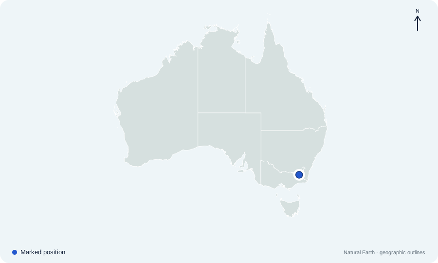
Which mainland summit is marked near the New South Wales–Victoria border?
 Open map at full size ↗
Image source & credit
Map outlines: Natural Earth; quiz rendering: Quizpen. Source ↗ · Public domain geographic data. Resized for display.
Reveal answer
Mount Kosciuszko. Mount Kosciuszko is in New South Wales and is the highest peak on the Australian mainland.
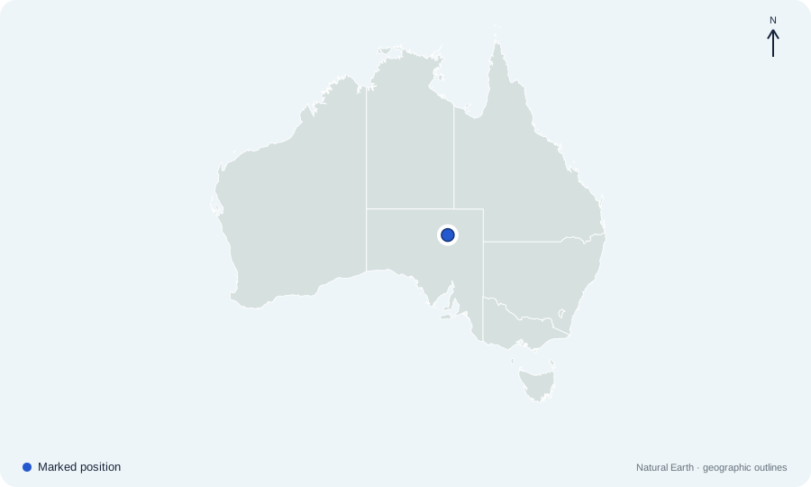
Which salt-lake basin is marked in northern South Australia?
 Open map at full size ↗
Image source & credit
Map outlines: Natural Earth; quiz rendering: Quizpen. Source ↗ · Public domain geographic data. Resized for display.
Reveal answer
Kati Thanda–Lake Eyre. Kati Thanda–Lake Eyre lies in South Australia’s arid interior, below sea level.
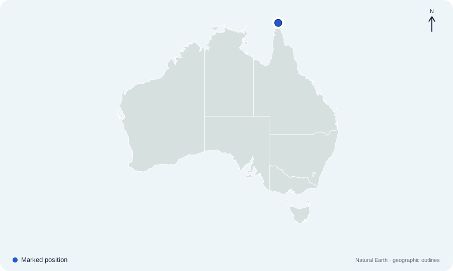
Which peninsula ends near the marked northern tip of Queensland?
 Open map at full size ↗
Image source & credit
Map outlines: Natural Earth; quiz rendering: Quizpen. Source ↗ · Public domain geographic data. Resized for display.
Reveal answer
Cape York Peninsula. Cape York Peninsula projects north from Queensland toward New Guinea.
Sources for this answer
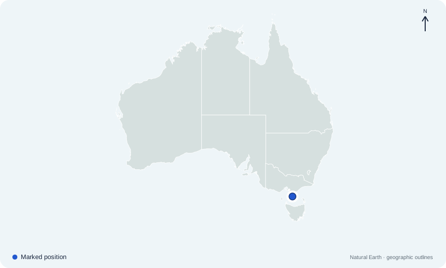
Which strait is marked between Tasmania and the mainland?
 Open map at full size ↗
Image source & credit
Map outlines: Natural Earth; quiz rendering: Quizpen. Source ↗ · Public domain geographic data. Resized for display.
Reveal answer
Bass Strait. Bass Strait separates Tasmania from Victoria on the Australian mainland.
Sources for this answer
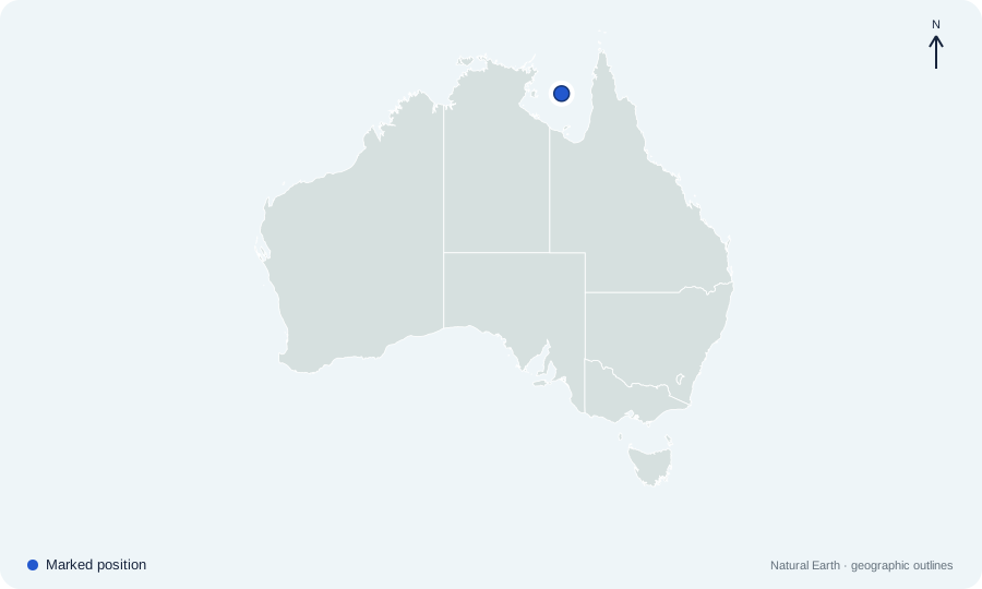
Which large gulf is marked between Queensland and the Northern Territory?
 Open map at full size ↗
Image source & credit
Map outlines: Natural Earth; quiz rendering: Quizpen. Source ↗ · Public domain geographic data. Resized for display.
Reveal answer
Gulf of Carpentaria. The Gulf of Carpentaria indents Australia’s northern coast between Cape York and Arnhem Land.
Sources for this answer
Which broad coastal indentation is marked along southern Australia?
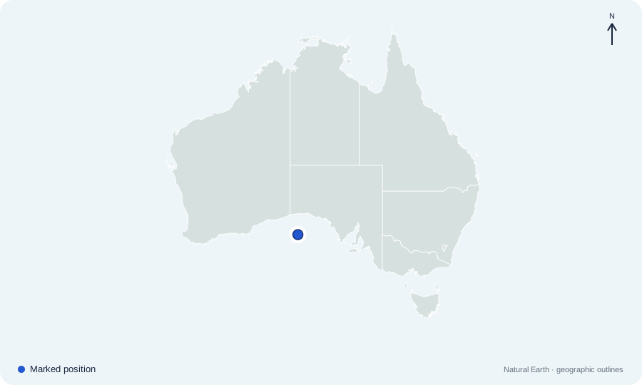 Open map at full size ↗
Image source & credit
Map outlines: Natural Earth; quiz rendering: Quizpen. Source ↗ · Public domain geographic data. Resized for display.
Reveal answer
Great Australian Bight. The Great Australian Bight curves along the southern coast of Western Australia and South Australia.
Sources for this answer
Which strait is marked immediately north of Cape York?
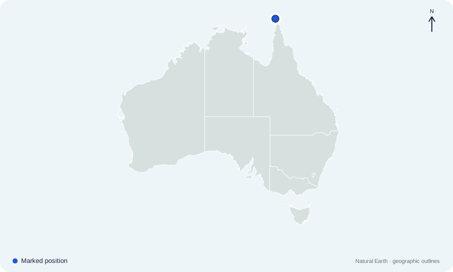 Open map at full size ↗
Image source & credit
Map outlines: Natural Earth; quiz rendering: Quizpen. Source ↗ · Public domain geographic data. Resized for display.
Reveal answer
Torres Strait. Torres Strait separates northern Australia from New Guinea.
The marker off Queensland’s northeast coast indicates which reef region?
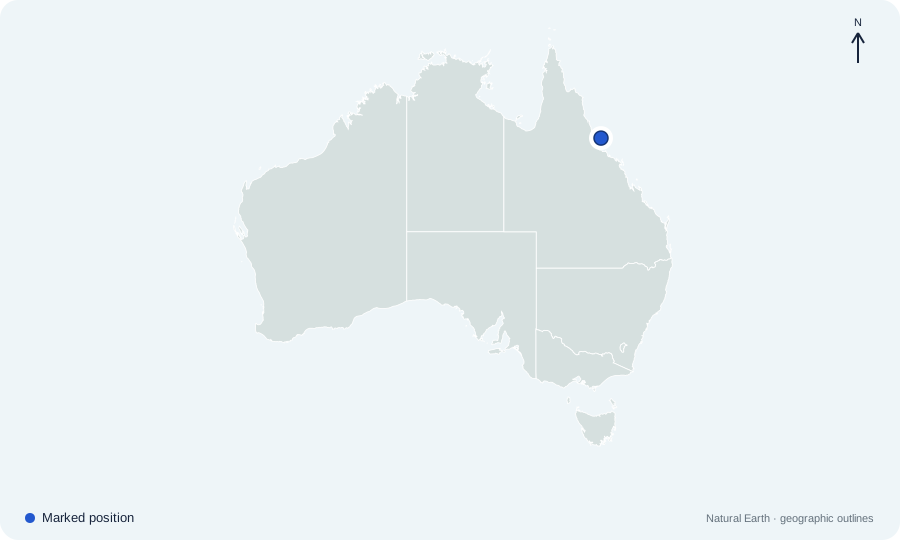 Open map at full size ↗
Image source & credit
Map outlines: Natural Earth; quiz rendering: Quizpen. Source ↗ · Public domain geographic data. Resized for display.
Reveal answer
Great Barrier Reef. The Great Barrier Reef extends along Queensland’s northeast coast. The dot indicates a location within the broad reef region, not its whole extent.
Sources for this answer
Which large island is marked southwest of Adelaide?
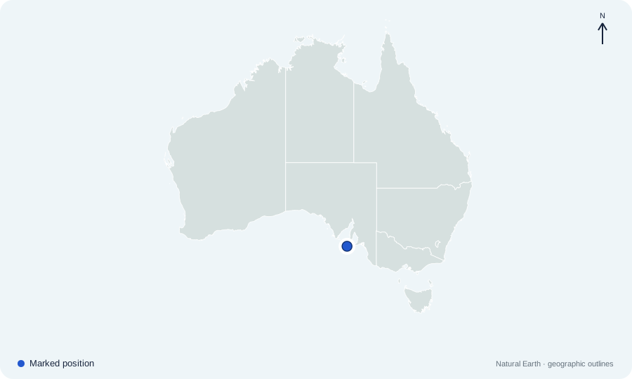 Open map at full size ↗
Image source & credit
Map outlines: Natural Earth; quiz rendering: Quizpen. Source ↗ · Public domain geographic data. Resized for display.
Reveal answer
Kangaroo Island. Kangaroo Island lies off the South Australian coast, southwest of Adelaide.
Which city is the capital of highlighted Western Australia?
Open map at full size ↗Image source & credit
Map outlines: Natural Earth; quiz rendering: Quizpen. Source ↗ · Public domain geographic data. Resized for display.
Reveal answer
Perth. Perth is the capital of Western Australia and lies near the southwest coast.
Sources for this answer
Which city is the capital of highlighted Queensland?
Open map at full size ↗Image source & credit
Map outlines: Natural Earth; quiz rendering: Quizpen. Source ↗ · Public domain geographic data. Resized for display.
Reveal answer
Brisbane. Brisbane is Queensland’s capital; Cairns, Townsville, and the Gold Coast are other Queensland urban centers.
Sources for this answer
Which city is the capital of highlighted South Australia?
Open map at full size ↗Image source & credit
Map outlines: Natural Earth; quiz rendering: Quizpen. Source ↗ · Public domain geographic data. Resized for display.
Reveal answer
Adelaide. Adelaide is South Australia’s capital, near the eastern shore of Gulf St Vincent.
Sources for this answer
Which city is the capital of highlighted Tasmania?
Open map at full size ↗Image source & credit
Map outlines: Natural Earth; quiz rendering: Quizpen. Source ↗ · Public domain geographic data. Resized for display.
Reveal answer
Hobart. Hobart is Tasmania’s capital, in the southeastern part of the island.
Sources for this answer
Which city is the capital of highlighted Victoria?
Open map at full size ↗Image source & credit
Map outlines: Natural Earth; quiz rendering: Quizpen. Source ↗ · Public domain geographic data. Resized for display.
Reveal answer
Melbourne. Melbourne is Victoria’s capital. Canberra is the national capital in a separate territory.
Sources for this answer
Which city is the capital of highlighted New South Wales?
Open map at full size ↗Image source & credit
Map outlines: Natural Earth; quiz rendering: Quizpen. Source ↗ · Public domain geographic data. Resized for display.
Reveal answer
Sydney. Sydney is the capital of New South Wales. Canberra lies within the separate Australian Capital Territory.
Sources for this answer
Which city is the capital of the highlighted Northern Territory?
Open map at full size ↗Image source & credit
Map outlines: Natural Earth; quiz rendering: Quizpen. Source ↗ · Public domain geographic data. Resized for display.
Reveal answer
Darwin. Darwin is the Northern Territory’s capital, on its northern coast.
Sources for this answer
Which city in the highlighted ACT is Australia’s national capital?
Open map at full size ↗Image source & credit
Map outlines: Natural Earth; quiz rendering: Quizpen. Source ↗ · Public domain geographic data. Resized for display.
Reveal answer
Canberra. Canberra is both the national capital and the capital of the Australian Capital Territory.
Sources for this answer
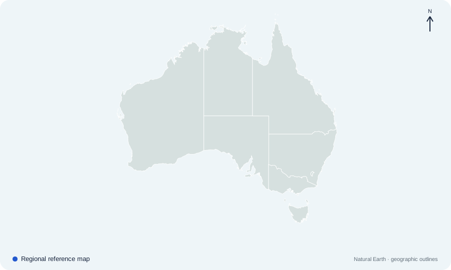
How many states does Australia have?
 Open map at full size ↗
Image source & credit
Map outlines: Natural Earth; quiz rendering: Quizpen. Source ↗ · Public domain geographic data. Resized for display.
Reveal answer
Six. Australia has six states. The ACT and Northern Territory are the two major mainland territories; Jervis Bay and external territories are separate jurisdictions, not additional states.
Sources for this answer
Which highlighted state is largest by area?
Open map at full size ↗Image source & credit
Map outlines: Natural Earth; quiz rendering: Quizpen. Source ↗ · Public domain geographic data. Resized for display.
Reveal answer
Western Australia. Western Australia is the largest Australian state by area and occupies the western portion of the mainland.
Sources for this answer
Which highlighted jurisdiction is completely surrounded by New South Wales?
Open map at full size ↗Image source & credit
Map outlines: Natural Earth; quiz rendering: Quizpen. Source ↗ · Public domain geographic data. Resized for display.
Reveal answer
Australian Capital Territory. The ACT is landlocked within New South Wales; Jervis Bay Territory is separately located on the coast.
Sources for this answer
Which two jurisdictions border Western Australia by land?
Open map at full size ↗Image source & credit
Map outlines: Natural Earth; quiz rendering: Quizpen. Source ↗ · Public domain geographic data. Resized for display.
Reveal answer
Northern Territory and South Australia. Western Australia’s eastern land border meets the Northern Territory in the north and South Australia in the south.
Sources for this answer
Which state borders every other mainland state?
Open map at full size ↗Image source & credit
Map outlines: Natural Earth; quiz rendering: Quizpen. Source ↗ · Public domain geographic data. Resized for display.
Reveal answer
South Australia. South Australia borders Western Australia, Queensland, New South Wales, and Victoria, as well as the Northern Territory. Tasmania is an island state.
Sources for this answer
Which river forms most of the boundary between New South Wales and Victoria?
Open map at full size ↗Image source & credit
Map outlines: Natural Earth; quiz rendering: Quizpen. Source ↗ · Public domain geographic data. Resized for display.
Reveal answer
Murray River. The Murray follows much of the NSW–Victoria boundary. The legal border generally follows the river’s southern bank.
Sources for this answer
Which ocean lies west of Western Australia?
Open map at full size ↗Image source & credit
Map outlines: Natural Earth; quiz rendering: Quizpen. Source ↗ · Public domain geographic data. Resized for display.
Reveal answer
Indian Ocean. Western Australia’s west coast faces the Indian Ocean.
Sources for this answer
Which sea lies off Queensland’s northeastern coast?
Open map at full size ↗Image source & credit
Map outlines: Natural Earth; quiz rendering: Quizpen. Source ↗ · Public domain geographic data. Resized for display.
Reveal answer
Coral Sea. The Coral Sea lies east of Queensland and includes the waters around the Great Barrier Reef.
Sources for this answer
Which sea separates southeastern Australia from New Zealand?
Open map at full size ↗Image source & credit
Map outlines: Natural Earth; quiz rendering: Quizpen. Source ↗ · Public domain geographic data. Resized for display.
Reveal answer
Tasman Sea. The Tasman Sea lies between southeastern Australia and New Zealand.
Sources for this answer
Which desert spans parts of Western Australia and South Australia?
Open map at full size ↗Image source & credit
Map outlines: Natural Earth; quiz rendering: Quizpen. Source ↗ · Public domain geographic data. Resized for display.
Reveal answer
Great Victoria Desert. The Great Victoria Desert stretches across parts of Western Australia and South Australia; its name does not place it in the state of Victoria.
Sources for this answer
Which three jurisdictions contain parts of the Simpson Desert?
Open map at full size ↗Image source & credit
Map outlines: Natural Earth; quiz rendering: Quizpen. Source ↗ · Public domain geographic data. Resized for display.
Reveal answer
Northern Territory, Queensland, and South Australia. The Simpson Desert lies near the meeting area of the Northern Territory, Queensland, and South Australia.
Sources for this answer
Answer key
- Western Australia. Western Australia occupies the broad western third of mainland Australia.
- Northern Territory. The Northern Territory lies in the north-central mainland; it is a territory, not a state.
- South Australia. South Australia occupies the central southern mainland.
- Queensland. Queensland occupies the northeastern mainland, including Cape York Peninsula.
- New South Wales. New South Wales lies on the eastern mainland, north of Victoria.
- Victoria. Victoria occupies the southeastern corner of the mainland, south of New South Wales.
- Tasmania. Tasmania is the island state south of the mainland across Bass Strait.
- Australian Capital Territory. The Australian Capital Territory is the small inland territory within New South Wales that contains Canberra.
- Jervis Bay Territory. Jervis Bay Territory is a small federal territory on the New South Wales coast. It is distinct from the landlocked ACT.
- Sydney. Sydney lies on the New South Wales coast. Its harbor-side position is east of the inland national capital, Canberra.
- Melbourne. Melbourne lies in southern Victoria at the head of Port Phillip Bay. Tasmania is farther south, across Bass Strait.
- Brisbane. Brisbane is in southeastern Queensland. It is much farther south than Cairns, even though both cities are in the same state.
- Perth. Perth is near Western Australia’s southwest coast. Its western position separates it clearly from the cluster of capitals on Australia’s eastern side.
- Adelaide. Adelaide lies beside Gulf St Vincent in South Australia. It is west of Melbourne, near the eastern end of the state’s southern coastline.
- Hobart. Hobart lies in southeastern Tasmania on the River Derwent. Its island location distinguishes it from the mainland capitals.
- Canberra. Canberra lies inland in the ACT, within New South Wales. Sydney and Melbourne are separate state capitals, not Australia’s national capital.
- Darwin. Darwin is on the far northern coast of the Northern Territory. Alice Springs is also in that territory but lies deep in the interior.
- Cairns. Cairns lies on the coast of far northern Queensland, close to the Great Barrier Reef region. It is well north of Brisbane and the Gold Coast.
- Alice Springs. Alice Springs lies in the Northern Territory’s central interior. Its inland location distinguishes it from Darwin, the territory’s coastal capital.
- Broome. Broome is a coastal town in northwestern Western Australia, in the Kimberley region. It lies far north of Perth.
- Gold Coast. The Gold Coast lies on Queensland’s southeastern coast, south of Brisbane and close to the New South Wales border.
- Uluru. Uluru is in the Northern Territory, southwest of Alice Springs. The marker shows the rock’s approximate location.
- Mount Kosciuszko. Mount Kosciuszko is in New South Wales and is the highest peak on the Australian mainland.
- Kati Thanda–Lake Eyre. Kati Thanda–Lake Eyre lies in South Australia’s arid interior, below sea level.
- Cape York Peninsula. Cape York Peninsula projects north from Queensland toward New Guinea.
- Bass Strait. Bass Strait separates Tasmania from Victoria on the Australian mainland.
- Gulf of Carpentaria. The Gulf of Carpentaria indents Australia’s northern coast between Cape York and Arnhem Land.
- Great Australian Bight. The Great Australian Bight curves along the southern coast of Western Australia and South Australia.
- Torres Strait. Torres Strait separates northern Australia from New Guinea.
- Great Barrier Reef. The Great Barrier Reef extends along Queensland’s northeast coast. The dot indicates a location within the broad reef region, not its whole extent.
- Kangaroo Island. Kangaroo Island lies off the South Australian coast, southwest of Adelaide.
- Perth. Perth is the capital of Western Australia and lies near the southwest coast.
- Brisbane. Brisbane is Queensland’s capital; Cairns, Townsville, and the Gold Coast are other Queensland urban centers.
- Adelaide. Adelaide is South Australia’s capital, near the eastern shore of Gulf St Vincent.
- Hobart. Hobart is Tasmania’s capital, in the southeastern part of the island.
- Melbourne. Melbourne is Victoria’s capital. Canberra is the national capital in a separate territory.
- Sydney. Sydney is the capital of New South Wales. Canberra lies within the separate Australian Capital Territory.
- Darwin. Darwin is the Northern Territory’s capital, on its northern coast.
- Canberra. Canberra is both the national capital and the capital of the Australian Capital Territory.
- Six. Australia has six states. The ACT and Northern Territory are the two major mainland territories; Jervis Bay and external territories are separate jurisdictions, not additional states.
- Western Australia. Western Australia is the largest Australian state by area and occupies the western portion of the mainland.
- Australian Capital Territory. The ACT is landlocked within New South Wales; Jervis Bay Territory is separately located on the coast.
- Northern Territory and South Australia. Western Australia’s eastern land border meets the Northern Territory in the north and South Australia in the south.
- South Australia. South Australia borders Western Australia, Queensland, New South Wales, and Victoria, as well as the Northern Territory. Tasmania is an island state.
- Murray River. The Murray follows much of the NSW–Victoria boundary. The legal border generally follows the river’s southern bank.
- Indian Ocean. Western Australia’s west coast faces the Indian Ocean.
- Coral Sea. The Coral Sea lies east of Queensland and includes the waters around the Great Barrier Reef.
- Tasman Sea. The Tasman Sea lies between southeastern Australia and New Zealand.
- Great Victoria Desert. The Great Victoria Desert stretches across parts of Western Australia and South Australia; its name does not place it in the state of Victoria.
- Northern Territory, Queensland, and South Australia. The Simpson Desert lies near the meeting area of the Northern Territory, Queensland, and South Australia.