
Geography / 10 questions
South America map quiz
Recognize the continent’s countries, capitals, borders, and coasts.
About 3–5 minutes · No timer
10 random questions per round · 50 questions in the full bank below
Published by Quizpen · Explanations include linked supporting reading. See our source-checking process and review limits.
Getting your round ready…
BEHIND THE ROUND
A little more about this quiz
Chile’s narrow Pacific coastline, Brazil’s broad Atlantic side, and the two landlocked countries are useful anchors for learning South America. This quiz combines country identification with capitals, neighboring countries, languages, and landmarks such as the Andes, the Galápagos, and Lake Titicaca.
The bank covers all twelve sovereign countries, with ten of fifty questions drawn for each round. French Guiana is described as part of France. Questions about Bolivia distinguish Sucre, the constitutional capital, from La Paz, the seat of government. Every question includes a geographic map for context.
LEARN THE PATTERN
Connect South American countries, capitals, and coasts
Practice the twelve outlines first, attach a capital to each country, and then use coastlines and neighboring countries to check your answer.
The 12 South American countries and their capitals
Cover the capital column and recall each pair. Then find the country on a map, so its name and capital stay connected with a location.
| Sovereign country | Capital | Distinction to remember |
|---|---|---|
| Argentina | Buenos Aires | Separate the federal capital from the province with the same name |
| Bolivia | Sucre | Constitutional capital; La Paz is the seat of government |
| Brazil | Brasília | The capital is not Rio de Janeiro or São Paulo |
| Chile | Santiago | Keep the country and capital names distinct |
| Colombia | Bogotá | Retain the accent when writing the Spanish name |
| Ecuador | Quito | Pair this capital with Ecuador rather than Peru |
| Guyana | Georgetown | Separate Guyana from neighboring Suriname |
| Paraguay | Asunción | Paraguay and Bolivia are the two landlocked countries |
| Peru | Lima | Recall the capital before revealing the choices |
| Suriname | Paramaribo | Separate this pair from Guyana–Georgetown |
| Uruguay | Montevideo | Separate this pair from Argentina–Buenos Aires |
| Venezuela | Caracas | Keep this pair distinct from Colombia–Bogotá |
Reference sources: OAS: country and capital directory · OAS: Bolivia, constitutional capital and seat of government · UN Statistics: countries, areas, and regional groupings
Check what you remember
Look away from the table. Try each question, then open it to check your answer.
Which two sovereign countries are landlocked, and what are their capitals?Show answer
Bolivia, with constitutional capital Sucre, and Paraguay, with capital Asunción. La Paz is Bolivia’s seat of government.
Name the capitals of Guyana and Suriname without looking at the table.Show answer
Guyana–Georgetown and Suriname–Paramaribo. They are separate neighboring countries.
Why is French Guiana not a thirteenth sovereign country in the quiz?Show answer
French Guiana is part of France. It appears in a status question rather than the twelve-country sovereign list.
Anchor the continent before naming the small outlines
Use Brazil’s broad eastern position and Chile’s narrow western shape as starting points. Bolivia and Paraguay are the two landlocked sovereign countries. Revisit the numbered map questions without answer choices, then explain why the highlighted outline fits the country you named.
Learn capitals in both directions
Recall the capital from a country, then name the country from its capital. Practice Guyana–Georgetown and Suriname–Paramaribo together to keep the neighboring countries distinct. A Bolivia question can ask for Sucre, the constitutional capital, or La Paz, the seat of government; those roles are different.
Check what the question asks you to count
French Guiana is part of France, so it is not a thirteenth sovereign country in this bank. Capital, language, border, and landform questions ask for different kinds of answers. After a missed question, name that kind of fact before reading the explanation again.
Put it into practice
Further reading: OAS: country and capital directory · OAS: Bolivia, constitutional capital and seat of government · UN Statistics: countries, areas, and regional groupings
QUESTIONS & ANSWERS
South America map quiz: the full question sheet
Recognize all 12 sovereign countries, connect them to their capitals, and explore borders, coasts, and landmarks in ten-question rounds from a bank of 50.
By Quizpen · Updated
Browse the full question bank50 questions & answers
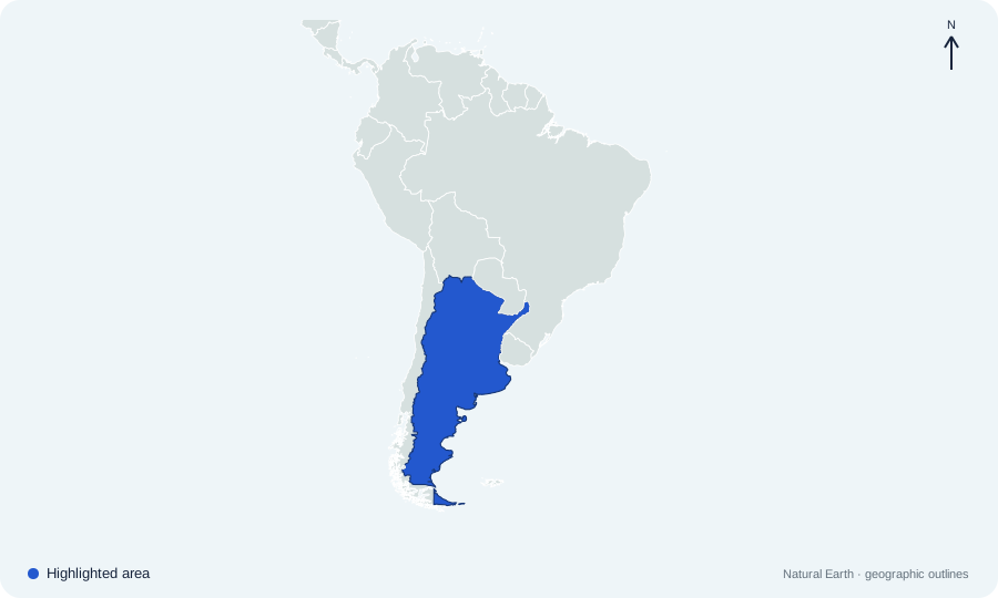
Which country is highlighted on South America map 01?
 Open map at full size ↗
Image source & credit
Map outlines: Natural Earth; quiz rendering: Quizpen. Source ↗ · Public domain geographic data. Resized for display.
Reveal answer
Argentina. Argentina occupies much of southeastern South America, east of the Andes.
Sources for this answer
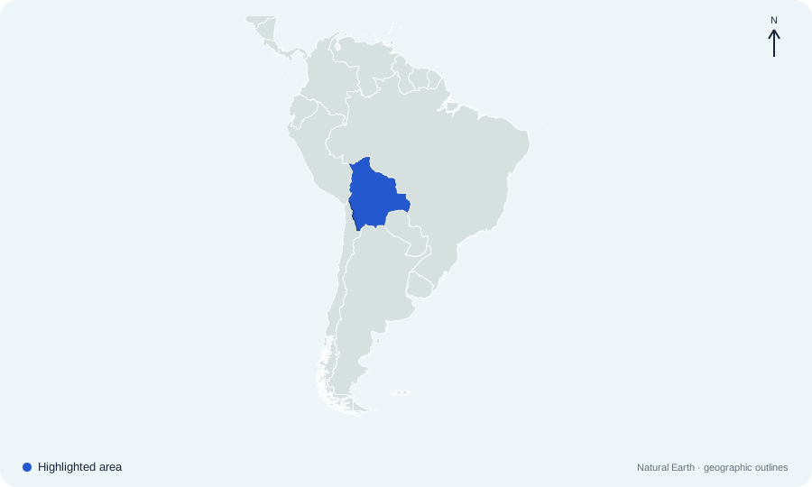
Which country is highlighted on South America map 02?
 Open map at full size ↗
Image source & credit
Map outlines: Natural Earth; quiz rendering: Quizpen. Source ↗ · Public domain geographic data. Resized for display.
Reveal answer
Bolivia. Bolivia is landlocked in the central-western part of South America.
Sources for this answer
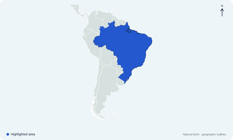
Which country is highlighted on South America map 03?
 Open map at full size ↗
Image source & credit
Map outlines: Natural Earth; quiz rendering: Quizpen. Source ↗ · Public domain geographic data. Resized for display.
Reveal answer
Brazil. Brazil is the continent’s largest country and has a long Atlantic coast.
Sources for this answer
Which country is highlighted on South America map 04?
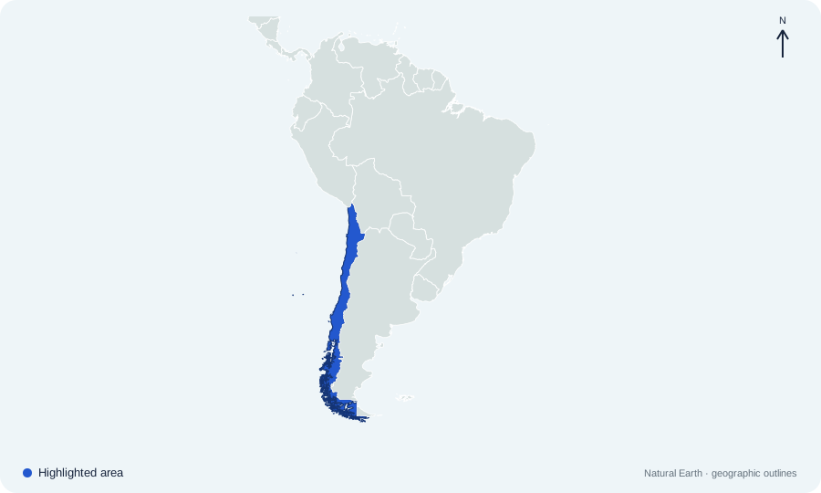 Open map at full size ↗
Image source & credit
Map outlines: Natural Earth; quiz rendering: Quizpen. Source ↗ · Public domain geographic data. Resized for display.
Reveal answer
Chile. Chile is the long, narrow country on the Pacific side of the Andes.
Sources for this answer
Which country is highlighted on South America map 05?
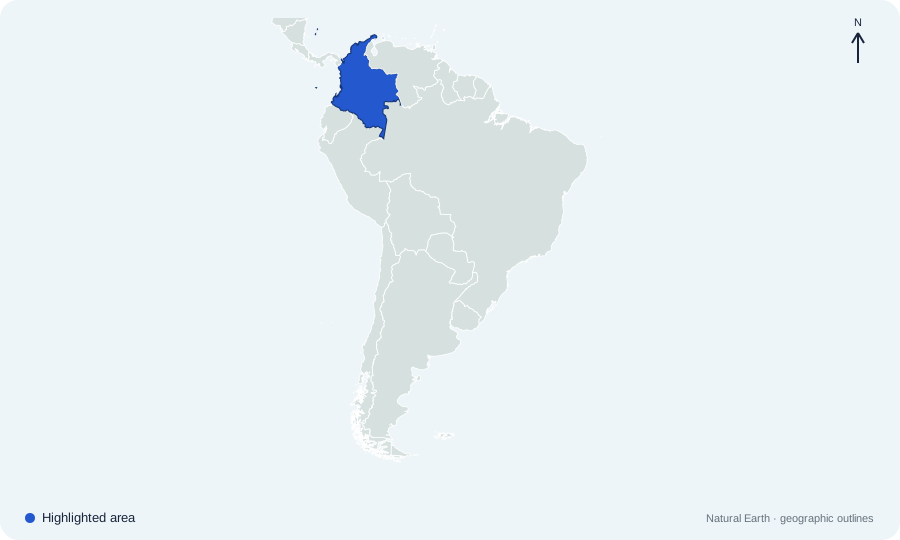 Open map at full size ↗
Image source & credit
Map outlines: Natural Earth; quiz rendering: Quizpen. Source ↗ · Public domain geographic data. Resized for display.
Reveal answer
Colombia. Colombia occupies the northwestern corner of South America and borders Panama.
Sources for this answer
Which country is highlighted on South America map 06?
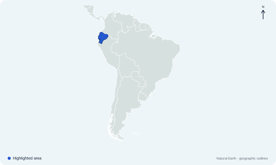 Open map at full size ↗
Image source & credit
Map outlines: Natural Earth; quiz rendering: Quizpen. Source ↗ · Public domain geographic data. Resized for display.
Reveal answer
Ecuador. Ecuador lies on the Pacific coast between Colombia and Peru.
Sources for this answer
Which country is highlighted on South America map 07?
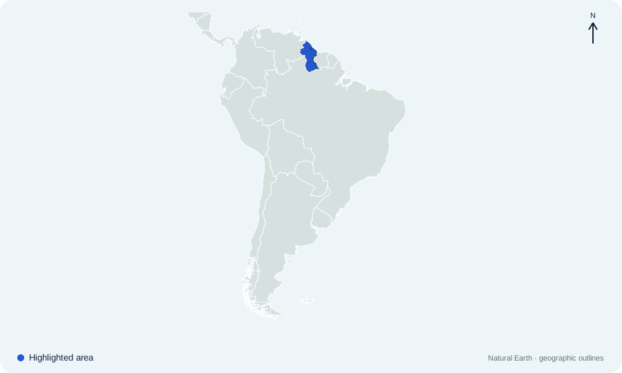 Open map at full size ↗
Image source & credit
Map outlines: Natural Earth; quiz rendering: Quizpen. Source ↗ · Public domain geographic data. Resized for display.
Reveal answer
Guyana. Guyana lies on the northern Atlantic coast, between Venezuela and Suriname.
Sources for this answer
Which country is highlighted on South America map 08?
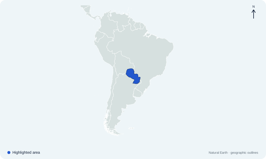 Open map at full size ↗
Image source & credit
Map outlines: Natural Earth; quiz rendering: Quizpen. Source ↗ · Public domain geographic data. Resized for display.
Reveal answer
Paraguay. Paraguay is landlocked between Bolivia, Brazil, and Argentina.
Sources for this answer
Which country is highlighted on South America map 09?
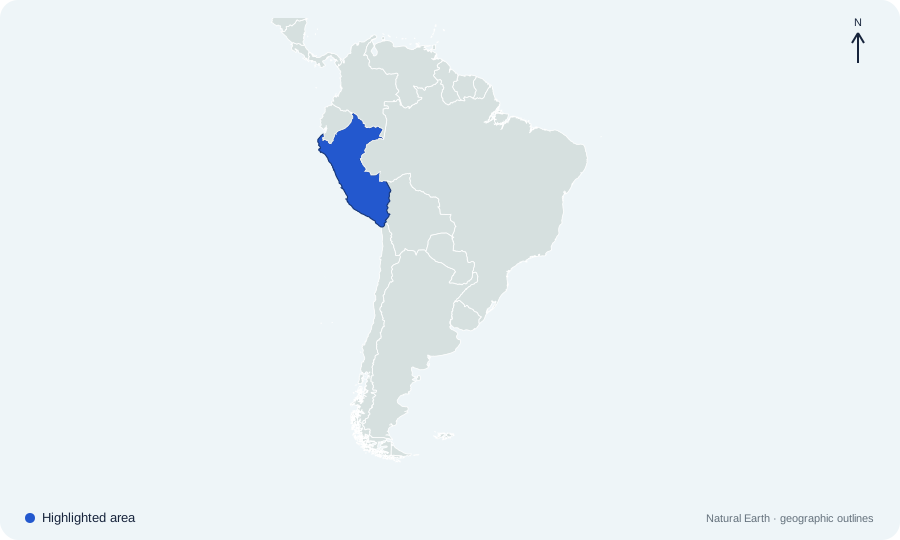 Open map at full size ↗
Image source & credit
Map outlines: Natural Earth; quiz rendering: Quizpen. Source ↗ · Public domain geographic data. Resized for display.
Reveal answer
Peru. Peru lies on the Pacific coast, south of Ecuador and Colombia.
Sources for this answer
Which country is highlighted on South America map 10?
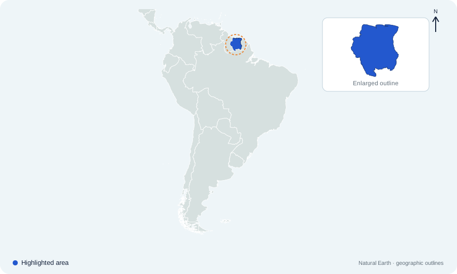 Open map at full size ↗
Image source & credit
Map outlines: Natural Earth; quiz rendering: Quizpen. Source ↗ · Public domain geographic data. Resized for display.
Reveal answer
Suriname. Suriname is the small northern coastal country between Guyana and French Guiana.
Sources for this answer
Which country is highlighted on South America map 11?
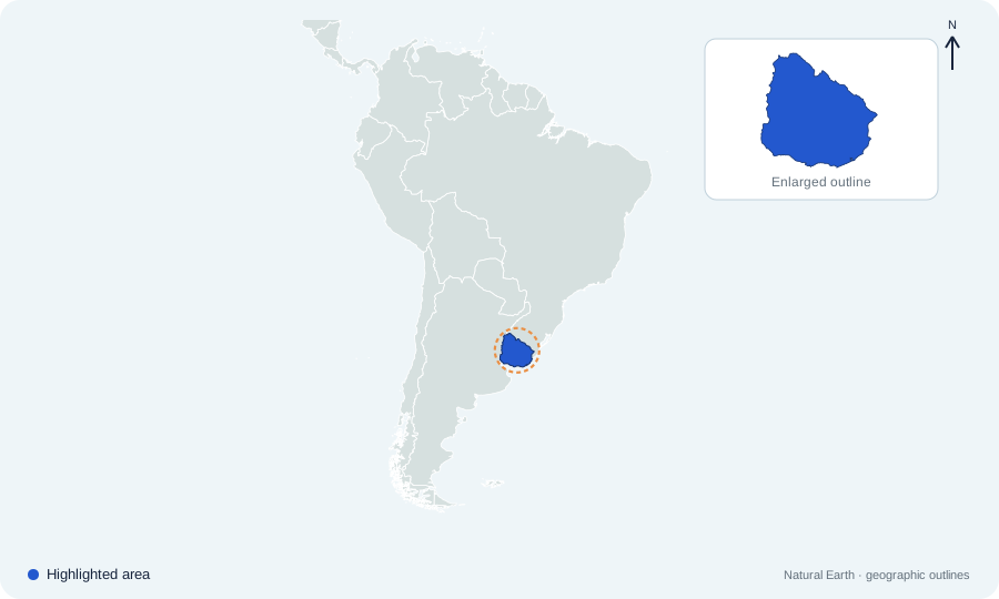 Open map at full size ↗
Image source & credit
Map outlines: Natural Earth; quiz rendering: Quizpen. Source ↗ · Public domain geographic data. Resized for display.
Reveal answer
Uruguay. Uruguay lies between Argentina and Brazil, beside the Río de la Plata and Atlantic.
Sources for this answer
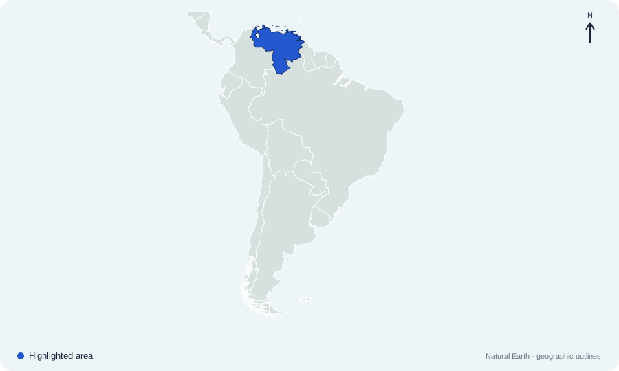
Which country is highlighted on South America map 12?
 Open map at full size ↗
Image source & credit
Map outlines: Natural Earth; quiz rendering: Quizpen. Source ↗ · Public domain geographic data. Resized for display.
Reveal answer
Venezuela. Venezuela lies on the continent’s northern Caribbean coast.
Sources for this answer
Which city is the capital of the country highlighted on South America map 13?
Open map at full size ↗Image source & credit
Map outlines: Natural Earth; quiz rendering: Quizpen. Source ↗ · Public domain geographic data. Resized for display.
Reveal answer
Buenos Aires. Buenos Aires is Argentina’s capital, beside the Río de la Plata estuary. Its eastern location is far from the Andes along the country’s western edge.
Sources for this answer
Which city is the constitutional capital of the highlighted landlocked country on map 14?
Open map at full size ↗Image source & credit
Map outlines: Natural Earth; quiz rendering: Quizpen. Source ↗ · Public domain geographic data. Resized for display.
Reveal answer
Sucre. Sucre is Bolivia’s constitutional capital. La Paz houses the executive and legislature, so a question asking for the seat of government has a different answer.
Sources for this answer
Which city is the capital of the country highlighted on South America map 15?
Open map at full size ↗Image source & credit
Map outlines: Natural Earth; quiz rendering: Quizpen. Source ↗ · Public domain geographic data. Resized for display.
Reveal answer
Brasília. Brasília is a planned inland capital built for the federal government. Its location contrasts with Brazil’s major coastal cities.
Sources for this answer
Which city is the capital of the country highlighted on South America map 16?
Open map at full size ↗Image source & credit
Map outlines: Natural Earth; quiz rendering: Quizpen. Source ↗ · Public domain geographic data. Resized for display.
Reveal answer
Santiago. Santiago lies inland in central Chile, near the Andes. Chile’s long shape places much of the country far north or south of its capital.
Sources for this answer
Which city is the capital of the country highlighted on South America map 17?
Open map at full size ↗Image source & credit
Map outlines: Natural Earth; quiz rendering: Quizpen. Source ↗ · Public domain geographic data. Resized for display.
Reveal answer
Bogotá. Bogotá is in the Colombian Andes, inland from both the Caribbean and Pacific coasts. A country with two ocean coastlines can still have an inland capital.
Sources for this answer
Which city is the capital of the country highlighted on South America map 18?
Open map at full size ↗Image source & credit
Map outlines: Natural Earth; quiz rendering: Quizpen. Source ↗ · Public domain geographic data. Resized for display.
Reveal answer
Quito. Quito stands high in Ecuador’s Andes, close to the equator. It is an inland mountain capital rather than a Pacific coastal city.
Sources for this answer
Which city is the capital of the country highlighted on South America map 19?
Open map at full size ↗Image source & credit
Map outlines: Natural Earth; quiz rendering: Quizpen. Source ↗ · Public domain geographic data. Resized for display.
Reveal answer
Georgetown. Georgetown is on Guyana’s Atlantic coast. That coastal position helps place it north of the country’s forested interior.
Sources for this answer
Which city is the capital of the country highlighted on South America map 20?
Open map at full size ↗Image source & credit
Map outlines: Natural Earth; quiz rendering: Quizpen. Source ↗ · Public domain geographic data. Resized for display.
Reveal answer
Asunción. Asunción stands beside the Paraguay River. Paraguay has a riverfront capital despite being one of South America’s two landlocked countries.
Sources for this answer
Which city is the capital of the country highlighted on South America map 21?
Open map at full size ↗Image source & credit
Map outlines: Natural Earth; quiz rendering: Quizpen. Source ↗ · Public domain geographic data. Resized for display.
Reveal answer
Lima. Lima lies in Peru’s Pacific coastal region. Cusco, often associated with Peru’s Inca history, is a different city in the Andes.
Sources for this answer
Which city is the capital of the country highlighted on South America map 22?
Open map at full size ↗Image source & credit
Map outlines: Natural Earth; quiz rendering: Quizpen. Source ↗ · Public domain geographic data. Resized for display.
Reveal answer
Paramaribo. Paramaribo stands on the Suriname River near the Atlantic coast. It is the capital of Suriname, whose official language is Dutch.
Sources for this answer
Which city is the capital of the country highlighted on South America map 23?
Open map at full size ↗Image source & credit
Map outlines: Natural Earth; quiz rendering: Quizpen. Source ↗ · Public domain geographic data. Resized for display.
Reveal answer
Montevideo. Montevideo lies on the Río de la Plata’s northern side. Buenos Aires, across the estuary region, is the capital of neighboring Argentina.
Sources for this answer
Which city is the capital of the country highlighted on South America map 24?
Open map at full size ↗Image source & credit
Map outlines: Natural Earth; quiz rendering: Quizpen. Source ↗ · Public domain geographic data. Resized for display.
Reveal answer
Caracas. Caracas lies inland in Venezuela’s northern coastal mountains. Its position near the Caribbean does not make it an island capital.
Sources for this answer
Which pair contains South America’s only two landlocked sovereign countries?
 Open map at full size ↗
Image source & credit
Map outlines: Natural Earth; quiz rendering: Quizpen. Source ↗ · Public domain geographic data. Resized for display.
Reveal answer
Bolivia and Paraguay. Bolivia and Paraguay have no coastline; all ten other sovereign South American countries reach an ocean or sea.
Sources for this answer
Which ocean lies west of highlighted Chile?
Open map at full size ↗Image source & credit
Map outlines: Natural Earth; quiz rendering: Quizpen. Source ↗ · Public domain geographic data. Resized for display.
Reveal answer
Pacific Ocean. Chile’s long western coastline faces the Pacific Ocean.
Sources for this answer
Which ocean borders highlighted Brazil?
Open map at full size ↗Image source & credit
Map outlines: Natural Earth; quiz rendering: Quizpen. Source ↗ · Public domain geographic data. Resized for display.
Reveal answer
Atlantic Ocean. Brazil occupies much of eastern South America and faces the Atlantic.
Sources for this answer
Which country forms the mainland link from South America to Central America?
Open map at full size ↗Image source & credit
Map outlines: Natural Earth; quiz rendering: Quizpen. Source ↗ · Public domain geographic data. Resized for display.
Reveal answer
Colombia. Colombia borders Panama, joining South America to the Central American isthmus.
Sources for this answer
Which mountain range runs along the western side of South America?
Open map at full size ↗Image source & credit
Map outlines: Natural Earth; quiz rendering: Quizpen. Source ↗ · Public domain geographic data. Resized for display.
Reveal answer
Andes. The Andes extend along the continent’s western margin, including the border zone between Chile and Argentina.
Sources for this answer
Which city is the seat of government of highlighted Bolivia?
Open map at full size ↗Image source & credit
Map outlines: Natural Earth; quiz rendering: Quizpen. Source ↗ · Public domain geographic data. Resized for display.
Reveal answer
La Paz. La Paz is Bolivia’s seat of government. Sucre is the constitutional capital, so these two civic roles should not be confused.
Sources for this answer
Which major rainforest occupies a large part of northern Brazil?
Open map at full size ↗Image source & credit
Map outlines: Natural Earth; quiz rendering: Quizpen. Source ↗ · Public domain geographic data. Resized for display.
Reveal answer
Amazon rainforest. The Amazon rainforest spans several countries, with its largest national share in Brazil.
The Río de la Plata separates parts of which two countries?
Open map at full size ↗Image source & credit
Map outlines: Natural Earth; quiz rendering: Quizpen. Source ↗ · Public domain geographic data. Resized for display.
Reveal answer
Argentina and Uruguay. Argentina lies to the southwest and Uruguay to the northeast of the Río de la Plata estuary.
Sources for this answer
Which two South American countries do not share a land border with Brazil?
Open map at full size ↗Image source & credit
Map outlines: Natural Earth; quiz rendering: Quizpen. Source ↗ · Public domain geographic data. Resized for display.
Reveal answer
Chile and Ecuador. Brazil borders every other South American sovereign country except Chile and Ecuador.
Sources for this answer
French Guiana, between Suriname and Brazil, is part of which country?
Open map at full size ↗Image source & credit
Map outlines: Natural Earth; quiz rendering: Quizpen. Source ↗ · Public domain geographic data. Resized for display.
Reveal answer
France. French Guiana is an overseas part of France, not a separate sovereign South American country.
Sources for this answer
What is the main official language of highlighted Brazil?
Open map at full size ↗Image source & credit
Map outlines: Natural Earth; quiz rendering: Quizpen. Source ↗ · Public domain geographic data. Resized for display.
Reveal answer
Portuguese. Portuguese is Brazil’s official language; neighboring Spanish-speaking countries do not make Brazil Spanish-speaking by default.
Sources for this answer
What is the official language of highlighted Suriname?
Open map at full size ↗Image source & credit
Map outlines: Natural Earth; quiz rendering: Quizpen. Source ↗ · Public domain geographic data. Resized for display.
Reveal answer
Dutch. Suriname’s official language is Dutch, although several other languages are widely spoken.
Sources for this answer
What is the official language of highlighted Guyana?
Open map at full size ↗Image source & credit
Map outlines: Natural Earth; quiz rendering: Quizpen. Source ↗ · Public domain geographic data. Resized for display.
Reveal answer
English. English is Guyana’s official language. Guyana and neighboring Suriname have different language histories.
Sources for this answer
The equator gives which highlighted country its name?
Open map at full size ↗Image source & credit
Map outlines: Natural Earth; quiz rendering: Quizpen. Source ↗ · Public domain geographic data. Resized for display.
Reveal answer
Ecuador. Ecuador takes its name from the equator, which crosses the country north of Quito.
Sources for this answer
Which two countries share Lake Titicaca?
Open map at full size ↗Image source & credit
Map outlines: Natural Earth; quiz rendering: Quizpen. Source ↗ · Public domain geographic data. Resized for display.
Reveal answer
Peru and Bolivia. Lake Titicaca lies on the Peru–Bolivia border in the Andes.
Sources for this answer
The Galápagos Islands belong to which highlighted country?
Open map at full size ↗Image source & credit
Map outlines: Natural Earth; quiz rendering: Quizpen. Source ↗ · Public domain geographic data. Resized for display.
Reveal answer
Ecuador. The Galápagos are Ecuadorian islands in the Pacific, well west of the mainland map.
Sources for this answer
Patagonia spans southern portions of which two countries?
Open map at full size ↗Image source & credit
Map outlines: Natural Earth; quiz rendering: Quizpen. Source ↗ · Public domain geographic data. Resized for display.
Reveal answer
Argentina and Chile. Patagonia extends across southern Argentina and Chile, on both sides of the Andes.
Sources for this answer
The Atacama Desert lies mainly in which highlighted country?
Open map at full size ↗Image source & credit
Map outlines: Natural Earth; quiz rendering: Quizpen. Source ↗ · Public domain geographic data. Resized for display.
Reveal answer
Chile. The Atacama lies in northern Chile, along the dry Pacific side of the Andes.
Sources for this answer
Which sea lies directly north of much of highlighted Venezuela?
Open map at full size ↗Image source & credit
Map outlines: Natural Earth; quiz rendering: Quizpen. Source ↗ · Public domain geographic data. Resized for display.
Reveal answer
Caribbean Sea. Venezuela has a long Caribbean coast on South America’s northern edge.
Sources for this answer
Which two countries border highlighted Uruguay by land?
Open map at full size ↗Image source & credit
Map outlines: Natural Earth; quiz rendering: Quizpen. Source ↗ · Public domain geographic data. Resized for display.
Reveal answer
Argentina and Brazil. Uruguay’s only land neighbors are Argentina to the west and Brazil to the north.
Sources for this answer
Highlighted Paraguay borders which three sovereign countries?
Open map at full size ↗Image source & credit
Map outlines: Natural Earth; quiz rendering: Quizpen. Source ↗ · Public domain geographic data. Resized for display.
Reveal answer
Argentina, Bolivia, and Brazil. Paraguay is enclosed by Bolivia to the northwest, Brazil to the east, and Argentina to the south and west.
Sources for this answer
Which country lies between Venezuela and Suriname on the Atlantic coast?
Open map at full size ↗Image source & credit
Map outlines: Natural Earth; quiz rendering: Quizpen. Source ↗ · Public domain geographic data. Resized for display.
Reveal answer
Guyana. Guyana lies east of Venezuela and west of Suriname on the continent’s northern coast.
Sources for this answer
Which neighboring country lies directly west of highlighted Suriname?
Open map at full size ↗Image source & credit
Map outlines: Natural Earth; quiz rendering: Quizpen. Source ↗ · Public domain geographic data. Resized for display.
Reveal answer
Guyana. Guyana borders Suriname to the west; French Guiana is to the east.
Sources for this answer
Which country borders both the Caribbean Sea and the Pacific Ocean?
Open map at full size ↗Image source & credit
Map outlines: Natural Earth; quiz rendering: Quizpen. Source ↗ · Public domain geographic data. Resized for display.
Reveal answer
Colombia. Colombia has a northern Caribbean coast and a western Pacific coast.
Sources for this answer
Which country borders Peru to the north along with Ecuador?
Open map at full size ↗Image source & credit
Map outlines: Natural Earth; quiz rendering: Quizpen. Source ↗ · Public domain geographic data. Resized for display.
Reveal answer
Colombia. Peru’s northern neighbors are Ecuador and Colombia.
Sources for this answer
Which country lies east of Chile across much of the Andes?
Open map at full size ↗Image source & credit
Map outlines: Natural Earth; quiz rendering: Quizpen. Source ↗ · Public domain geographic data. Resized for display.
Reveal answer
Argentina. Argentina and Chile share a long border that follows much of the Andes.
Sources for this answer
Answer key
- Argentina. Argentina occupies much of southeastern South America, east of the Andes.
- Bolivia. Bolivia is landlocked in the central-western part of South America.
- Brazil. Brazil is the continent’s largest country and has a long Atlantic coast.
- Chile. Chile is the long, narrow country on the Pacific side of the Andes.
- Colombia. Colombia occupies the northwestern corner of South America and borders Panama.
- Ecuador. Ecuador lies on the Pacific coast between Colombia and Peru.
- Guyana. Guyana lies on the northern Atlantic coast, between Venezuela and Suriname.
- Paraguay. Paraguay is landlocked between Bolivia, Brazil, and Argentina.
- Peru. Peru lies on the Pacific coast, south of Ecuador and Colombia.
- Suriname. Suriname is the small northern coastal country between Guyana and French Guiana.
- Uruguay. Uruguay lies between Argentina and Brazil, beside the Río de la Plata and Atlantic.
- Venezuela. Venezuela lies on the continent’s northern Caribbean coast.
- Buenos Aires. Buenos Aires is Argentina’s capital, beside the Río de la Plata estuary. Its eastern location is far from the Andes along the country’s western edge.
- Sucre. Sucre is Bolivia’s constitutional capital. La Paz houses the executive and legislature, so a question asking for the seat of government has a different answer.
- Brasília. Brasília is a planned inland capital built for the federal government. Its location contrasts with Brazil’s major coastal cities.
- Santiago. Santiago lies inland in central Chile, near the Andes. Chile’s long shape places much of the country far north or south of its capital.
- Bogotá. Bogotá is in the Colombian Andes, inland from both the Caribbean and Pacific coasts. A country with two ocean coastlines can still have an inland capital.
- Quito. Quito stands high in Ecuador’s Andes, close to the equator. It is an inland mountain capital rather than a Pacific coastal city.
- Georgetown. Georgetown is on Guyana’s Atlantic coast. That coastal position helps place it north of the country’s forested interior.
- Asunción. Asunción stands beside the Paraguay River. Paraguay has a riverfront capital despite being one of South America’s two landlocked countries.
- Lima. Lima lies in Peru’s Pacific coastal region. Cusco, often associated with Peru’s Inca history, is a different city in the Andes.
- Paramaribo. Paramaribo stands on the Suriname River near the Atlantic coast. It is the capital of Suriname, whose official language is Dutch.
- Montevideo. Montevideo lies on the Río de la Plata’s northern side. Buenos Aires, across the estuary region, is the capital of neighboring Argentina.
- Caracas. Caracas lies inland in Venezuela’s northern coastal mountains. Its position near the Caribbean does not make it an island capital.
- Bolivia and Paraguay. Bolivia and Paraguay have no coastline; all ten other sovereign South American countries reach an ocean or sea.
- Pacific Ocean. Chile’s long western coastline faces the Pacific Ocean.
- Atlantic Ocean. Brazil occupies much of eastern South America and faces the Atlantic.
- Colombia. Colombia borders Panama, joining South America to the Central American isthmus.
- Andes. The Andes extend along the continent’s western margin, including the border zone between Chile and Argentina.
- La Paz. La Paz is Bolivia’s seat of government. Sucre is the constitutional capital, so these two civic roles should not be confused.
- Amazon rainforest. The Amazon rainforest spans several countries, with its largest national share in Brazil.
- Argentina and Uruguay. Argentina lies to the southwest and Uruguay to the northeast of the Río de la Plata estuary.
- Chile and Ecuador. Brazil borders every other South American sovereign country except Chile and Ecuador.
- France. French Guiana is an overseas part of France, not a separate sovereign South American country.
- Portuguese. Portuguese is Brazil’s official language; neighboring Spanish-speaking countries do not make Brazil Spanish-speaking by default.
- Dutch. Suriname’s official language is Dutch, although several other languages are widely spoken.
- English. English is Guyana’s official language. Guyana and neighboring Suriname have different language histories.
- Ecuador. Ecuador takes its name from the equator, which crosses the country north of Quito.
- Peru and Bolivia. Lake Titicaca lies on the Peru–Bolivia border in the Andes.
- Ecuador. The Galápagos are Ecuadorian islands in the Pacific, well west of the mainland map.
- Argentina and Chile. Patagonia extends across southern Argentina and Chile, on both sides of the Andes.
- Chile. The Atacama lies in northern Chile, along the dry Pacific side of the Andes.
- Caribbean Sea. Venezuela has a long Caribbean coast on South America’s northern edge.
- Argentina and Brazil. Uruguay’s only land neighbors are Argentina to the west and Brazil to the north.
- Argentina, Bolivia, and Brazil. Paraguay is enclosed by Bolivia to the northwest, Brazil to the east, and Argentina to the south and west.
- Guyana. Guyana lies east of Venezuela and west of Suriname on the continent’s northern coast.
- Guyana. Guyana borders Suriname to the west; French Guiana is to the east.
- Colombia. Colombia has a northern Caribbean coast and a western Pacific coast.
- Colombia. Peru’s northern neighbors are Ecuador and Colombia.
- Argentina. Argentina and Chile share a long border that follows much of the Andes.