
Geography / Map practice
Great Lakes quiz
Name all five lakes on a map, then connect their shores and rivers.
Find locations · Recall names · Print a map · No timer
RECALL LAB
Recall the five lakes without answer choices
Name each highlighted lake, or reverse the task and select a named lake on the map. Every round includes all five once.
The conventional five Great Lakes are the target set. Lake St. Clair is a connecting water body, not a sixth target.
Untimed practice. Each target appears once. Check an answer before moving on, then revisit missed items. Results stay in this activity for this visit; your saved quiz round remains available below.
Study the complete target set and sources
| Target | Recall cue |
|---|---|
| Lake Superior | Farthest west; the largest of the five by surface area. |
| Lake Michigan | West of Michigan’s Lower Peninsula; the only one entirely in the United States. |
| Lake Huron | East of Michigan’s Lower Peninsula, with Georgian Bay on its eastern side. |
| Lake Erie | South of Ontario; the shallowest of the five Great Lakes. |
| Lake Ontario | Farthest east; the St. Lawrence River carries its water toward the Atlantic. |
QUIZPEN · quizpen.com/quiz/great-lakes-quiz/
Five Great Lakes: blank practice sheet
Name: _____________________________ Date: ______________
Write the name for every numbered outline.
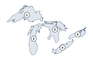
- ________________________________
- ________________________________
- ________________________________
- ________________________________
- ________________________________
The conventional five Great Lakes are the target set. Lake St. Clair is a connecting water body, not a sixth target.
QUIZPEN · SEPARATE ANSWER KEY
Five Great Lakes: answer key
- Lake Superior
- Lake Michigan
- Lake Huron
- Lake Erie
- Lake Ontario
The conventional five Great Lakes are the target set. Lake St. Clair is a connecting water body, not a sixth target.
Sources: https://www.glerl.noaa.gov/education/ourlakes/lakes.html · https://www.epa.gov/system/files/documents/2025-03/p1004icu.pdf
10 random questions per mixed round · 50 questions in the full bank below
Published by Quizpen · Explanations include linked supporting reading. See our source-checking process and review limits.
PRACTICE BY SKILL
Choose a focused round
Practice one part of this topic with every question in that skill. Focused practice is separate from ten-question mixed rounds.
Getting your round ready…
BEHIND THE ROUND
A little more about this quiz
The five Great Lakes are Superior, Michigan, Huron, Erie, and Ontario. Start with the five-lake map round to identify every lake, or use typed recall to name them without answer choices. HOMES helps you remember the names; the map and waterway practice help you put those names in the right places.
The 50-question bank goes beyond naming the lakes: compare surface area, depth, and volume, match cities with their shores, and follow the rivers toward the St. Lawrence. A mixed round draws ten questions. Focused practice separates lake maps, facts, cities, landmarks, and the environment so you can revisit the kind of question you missed.
For a paper activity, print the numbered blank map and its answer key from the recall lab, or select questions in the worksheet builder. The study guide and five-lake reference table below explain the map clues and common mix-ups, using NOAA, EPA, and Canadian government references.
LEARN THE PATTERN
Learn all five Great Lakes, then follow their waterways
Name Superior, Michigan, Huron, Erie, and Ontario on a blank map, then check the location clues below. Start with the five-map practice round for lake identification; the rest of the bank adds sizes, connecting rivers, cities, landmarks, and environmental questions.
The five Great Lakes: names, map clues, and connections
HOMES stands for Huron, Ontario, Michigan, Erie, and Superior. Learn those five names, then cover the first column and identify each lake from its position.
| Lake | Map clue | Comparison to remember | Connection toward the outlet |
|---|---|---|---|
| Superior | Farthest west; Duluth at its western end | Largest area, most water, greatest maximum depth | St. Marys River to Huron |
| Michigan | West of Michigan’s Lower Peninsula; Chicago near the south end | Entirely in the United States | Straits of Mackinac connect it with Huron |
| Huron | East of Michigan’s Lower Peninsula; includes Georgian Bay | Second-largest surface area | St. Clair River toward Lake St. Clair |
| Erie | South of Ontario; Cleveland on the southern shore | Least water; shallowest average depth | Niagara River to Ontario |
| Ontario | Farthest east; Toronto on the northern shore | Smallest surface area; lowest lake surface | St. Lawrence River toward the Atlantic |
Follow the connections: Superior → St. Marys River → Huron → St. Clair River → Lake St. Clair → Detroit River → Erie → Niagara River → Ontario → St. Lawrence River. Michigan joins Huron at the Straits of Mackinac; they share a surface elevation. The comparisons above treat Michigan and Huron as separately named lakes.
Reference sources: NOAA: lake measurements and outlets · Canada Water Agency: Great Lakes map · EPA: Lake Michigan · EPA: the Huron–Erie connection · EPA and Environment Canada: Great Lakes atlas and connecting channels
Check what you remember
Look away from the table. Try each question, then open it to check your answer.
Can you name all five lakes, including the one entirely within the United States?Show answer
Superior, Michigan, Huron, Erie, and Ontario. Lake Michigan lies entirely within the United States.
Which is second-largest by area: Michigan or Huron? Which holds more water?Show answer
Huron is second-largest by surface area. Michigan has the larger water volume and ranks second by that measure.
Which lake has the smallest surface area, and which is shallowest on average?Show answer
Ontario has the smallest surface area. Erie has the shallowest average depth.
Use HOMES for the names, then read the map
HOMES recalls Huron, Ontario, Michigan, Erie, and Superior; it does not give their geographic order. Start with Superior in the west and Ontario in the east. Michigan lies west of Michigan’s Lower Peninsula, while Huron lies to its east. Point to each outline before naming it.
A three-step blank-map exercise
Use the numbered blank-map worksheet in the recall lab for this exercise. Keep the reference table covered until you have attempted all five names.
- Anchor the ends: find Superior in the northwest and Ontario in the east.
- Use Michigan’s Lower Peninsula as the divider: Lake Michigan is to its west, Lake Huron to its east. Lake Erie lies south of Ontario.
- Check the five-name list for omissions, then add a shore-city pair: Chicago–Michigan, Cleveland–Erie, or Toronto–Ontario. On the next attempt, recall the lake from the city.
Ask which measurement a comparison uses
Superior leads the five separately named lakes in surface area, water volume, and maximum depth. Huron ranks second in area, but Michigan holds more water than Huron. Ontario has the smallest surface area; Erie is shallowest on average and holds the least water. Say the measurement aloud before answering “largest” or “smallest.”
Trace the connecting water instead of memorizing isolated rivers
Follow Superior through the St. Marys River to Huron, then the St. Clair River, Lake St. Clair, and Detroit River to Erie. The Niagara River connects Erie with Ontario, and the St. Lawrence carries Ontario’s water onward. Michigan and Huron meet at the Straits of Mackinac. Lake St. Clair is part of this route without becoming a sixth Great Lake.
Why are Michigan and Huron sometimes written as one lake?
They connect through the broad Straits of Mackinac and are treated as Michigan–Huron in water-level studies because they share a common mean water level. This quiz follows the five familiar lake names. For size questions, compare Michigan and Huron separately unless the question explicitly combines them. Lake Michigan is the only one of the five entirely within the United States.
Turn missed answers into a second round
For city questions, pair Chicago–Michigan, Cleveland–Erie, and Toronto–Ontario. For a paper round, choose map questions first and add waterway or shore questions in the worksheet builder. Have players write the lake name before showing the choices, then explain one map clue when checking the answer key.
Put it into practice
- Try a ten-question mixed round
- Download the Great Lakes mini-quiz & answer key (PDF · 2 pages)
- Try typed recall, maps and printable practice
- Identify all five lake maps
- Compare lake sizes and connecting rivers
- Match cities and shores
- Review landmarks and waterways
- Review the lake environment
- Build a Great Lakes worksheet
- Continue with Midwest states and capitals
Further reading: NOAA: lake measurements and outlets · Canada Water Agency: Great Lakes map · EPA: Lake Michigan · EPA: the Huron–Erie connection · EPA and Environment Canada: Great Lakes atlas and connecting channels · NOAA: Michigan–Huron and common mean water levels
QUESTIONS & ANSWERS
Great Lakes quiz: the full question sheet
Quiz Great Lakes outlines, shore cities, rivers, and parks. Draw 10 of 50 questions with explanations, printable sheet, and answer key.
By Quizpen · Updated
Browse the full question bank50 questions & answers
Which Great Lake is highlighted on lake map 1?
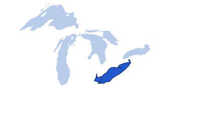
Lake outlines shown in their geographic positions. Reveal answer
Lake Erie. Erie is the long, relatively narrow lake south of Ontario and north of Ohio. The Niagara River carries its water toward Lake Ontario.
Sources for this answer
Which Great Lake is highlighted on lake map 2?
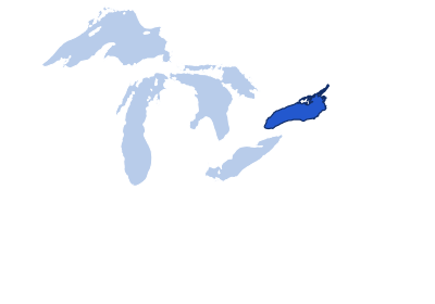
Lake outlines shown in their geographic positions. Reveal answer
Lake Ontario. Ontario is the easternmost of the five, between New York state and Ontario province. Its outlet is the St. Lawrence River.
Sources for this answer
Which Great Lake is highlighted on lake map 3?
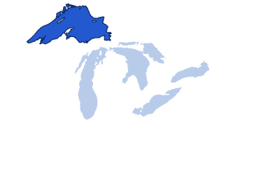
Lake outlines shown in their geographic positions. Reveal answer
Lake Superior. Superior is the broad northern and western lake, above Wisconsin and Michigan’s Upper Peninsula. It drains toward Huron through the St. Marys River.
Sources for this answer
Which Great Lake is highlighted on lake map 4?
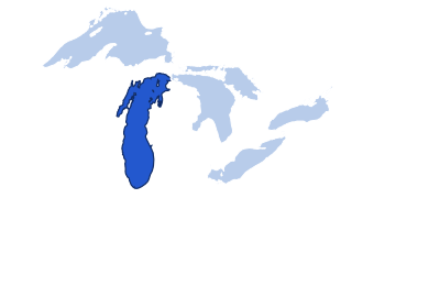
Lake outlines shown in their geographic positions. Reveal answer
Lake Michigan. Michigan extends south between Wisconsin and Michigan’s Lower Peninsula. It is the only Great Lake entirely within the United States.
Sources for this answer
Which Great Lake is highlighted on lake map 5?
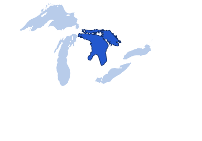
Lake outlines shown in their geographic positions. Reveal answer
Lake Huron. Huron is east of Michigan’s Lower Peninsula, with Georgian Bay projecting northeast. It connects to Michigan through the Straits of Mackinac.
Sources for this answer
How many lakes are conventionally called the Great Lakes?
Reveal answer
Five. The five conventional names are Superior, Michigan, Huron, Erie, and Ontario. Lake St. Clair connects part of the system but is not one of the five.
Sources for this answer
Which Great Lake has the largest surface area?
Reveal answer
Superior. Superior covers about 31,700 square miles. This compares the conventional five lakes separately; Michigan and Huron are also connected at the same water level.
Sources for this answer
Which Great Lake is the deepest?
Reveal answer
Superior. Superior reaches about 1,332 feet at its deepest point. Maximum depth measures a single deepest location, rather than the average depth across the lake.
Sources for this answer
Which Great Lake is entirely within the United States?
Reveal answer
Michigan. Lake Michigan lies entirely within US borders. The other four are shared with Canada.
Sources for this answer
Which Great Lake has the smallest surface area?
Reveal answer
Ontario. Ontario has about 7,340 square miles of water surface. Erie is larger in area but much shallower, so Erie holds less water.
Sources for this answer
Which Great Lake is the shallowest on average?
Reveal answer
Erie. Erie averages about 62 feet deep. Ontario has a smaller surface area but a much greater average depth, showing why area and depth are different comparisons.
Sources for this answer
Which Great Lake contains the least water by volume?
Reveal answer
Erie. Erie holds about 116 cubic miles of water in NOAA’s reference table. Its shallow basin gives it less volume than the smaller-surface-area Lake Ontario.
Sources for this answer
Which Great Lake is second-largest by surface area?
Reveal answer
Huron. Huron has about 23,000 square miles of surface, ahead of Michigan’s roughly 22,300. Volume is a different comparison, in which Michigan exceeds Huron.
Sources for this answer
Which pair is connected at the Straits of Mackinac?
Reveal answer
Michigan and Huron. Michigan and Huron connect through the Straits of Mackinac and share a surface level. They are conventionally named separately despite this hydrologic connection.
Sources for this answer
Which river carries water from Lake Superior toward Lake Huron?
Reveal answer
St. Marys River. The St. Marys River is Superior’s outlet toward Huron. Locks near Sault Ste. Marie help ships bypass the river’s rapids and elevation change.
Sources for this answer
Which river flows from Lake Erie to Lake Ontario?
Reveal answer
Niagara River. Water flows through the Niagara River from Erie down to Ontario. Niagara Falls lies on this connection; the Welland Canal provides a shipping bypass.
Sources for this answer
Which river carries Lake Ontario’s water toward the Atlantic?
Reveal answer
St. Lawrence River. Lake Ontario drains into the St. Lawrence River, leading toward the Gulf of St. Lawrence and Atlantic.
Sources for this answer
Niagara Falls lies between which two Great Lakes?
Reveal answer
Erie and Ontario. The Niagara River carries Erie’s water toward lower Lake Ontario. The falls are on a connecting river, not at the center of either lake.
Sources for this answer
Which canal lets ships bypass Niagara Falls?
Reveal answer
Welland Canal. The Welland Canal links Erie and Ontario while avoiding Niagara Falls. Its locks let vessels negotiate the difference in lake elevations.
Sources for this answer
Chicago is on the shore of which Great Lake?
Reveal answer
Michigan. Chicago lies on Lake Michigan’s southwestern shore. The lake extends northward past Milwaukee and toward the Straits of Mackinac.
Sources for this answer
Toronto is on which Great Lake?
Reveal answer
Ontario. Toronto is on Lake Ontario’s northwestern shore. Buffalo, farther southwest in New York, is associated with the eastern end of Lake Erie.
Sources for this answer
Cleveland is on which Great Lake?
Reveal answer
Erie. Cleveland sits on Lake Erie’s southern shore. Erie is the shallowest of the Great Lakes, and is shared by the United States and Canada.
Sources for this answer
Duluth, Minnesota, is on which Great Lake?
Reveal answer
Superior. Duluth is at Superior’s western end, beside Superior, Wisconsin. This harbor area marks the far-western reach of the Great Lakes system.
Sources for this answer
Milwaukee is on which Great Lake?
Reveal answer
Michigan. Milwaukee sits on Lake Michigan’s western shore, north of Chicago. Wisconsin also touches Lake Superior, but Milwaukee is not on that lake.
Sources for this answer
Buffalo, New York, is near the eastern end of which Great Lake?
Reveal answer
Erie. Buffalo is at Erie’s eastern end near the Niagara River outlet. Following that river downstream leads toward Niagara Falls and Lake Ontario.
Sources for this answer
Which US state has shoreline on four of the five Great Lakes?
Reveal answer
Michigan. Michigan borders Superior, Michigan, Huron, and Erie. It does not border Ontario.
Sources for this answer
Which Canadian province borders all four Great Lakes shared with the United States?
Reveal answer
Ontario. Ontario is the Canadian province bordering Superior, Huron, Erie, and Ontario. Lake Michigan is entirely within the United States.
Sources for this answer
Which Great Lake borders both New York state and the Canadian province of Ontario but no other US state?
Reveal answer
Ontario. Lake Ontario’s US shoreline is entirely in New York state. Erie also borders New York, but reaches Pennsylvania, Ohio, and Michigan as well.
Sources for this answer
Which Great Lake borders Minnesota, Wisconsin, and Michigan?
Reveal answer
Superior. Superior touches Minnesota, Wisconsin, and Michigan on the US side, and Ontario on the Canadian side. It extends farther west than the other four lakes.
Sources for this answer
Which Great Lake borders Illinois and Indiana?
Reveal answer
Michigan. Lake Michigan reaches both Illinois and Indiana at its southern end. Wisconsin and Michigan occupy the much longer western and eastern sides.
Sources for this answer
Isle Royale National Park is surrounded by which Great Lake?
Reveal answer
Superior. Isle Royale is an archipelago in northwestern Lake Superior. Despite its closeness to Minnesota and Canada, the national park is in Michigan.
Sources for this answer
Sleeping Bear Dunes National Lakeshore is on which Great Lake?
Reveal answer
Michigan. Sleeping Bear Dunes lies on Lake Michigan’s eastern side in Michigan’s Lower Peninsula. Its dunes are shoreline landforms, not mountains.
Sources for this answer
Pictured Rocks National Lakeshore is on which Great Lake?
Reveal answer
Superior. Pictured Rocks is on Lake Superior in Michigan’s Upper Peninsula. Sleeping Bear Dunes is a different Michigan lakeshore, beside Lake Michigan.
Sources for this answer
Georgian Bay is part of which Great Lake?
Reveal answer
Huron. Georgian Bay forms Huron’s large northeastern arm. It remains part of Lake Huron, rather than a sixth lake in the usual Great Lakes list.
Sources for this answer
Green Bay is an arm of which Great Lake?
Reveal answer
Michigan. Green Bay is the long bay on Lake Michigan’s northwestern side. The same name is also used for the Wisconsin city at its southwestern end.
Sources for this answer
The Apostle Islands are in which Great Lake?
Reveal answer
Superior. The Apostle Islands lie in Lake Superior off northern Wisconsin. They should not be confused with Isle Royale farther northeast in the same lake.
Sources for this answer
Manitoulin Island lies in which Great Lake?
Reveal answer
Huron. Manitoulin Island lies in northern Lake Huron. Its position helps separate the main lake basin from the North Channel and Georgian Bay.
Sources for this answer
Which bridge spans the straits between Michigan’s Upper and Lower Peninsulas?
Reveal answer
Mackinac Bridge. The Mackinac Bridge links Michigan’s two peninsulas across the straits joining Michigan and Huron. The bridge crosses the connecting waterway, not the full width of either lake.
Sources for this answer
The Soo Locks help vessels navigate between which lakes?
Reveal answer
Superior and Huron. The Soo Locks bypass rapids in the St. Marys River. Ships use them to move between higher Lake Superior and the lower Huron system.
Sources for this answer
Which river links Lake St. Clair to Lake Erie?
Reveal answer
Detroit River. The Detroit River drains Lake St. Clair into Erie. Upstream, the St. Clair River carries Huron’s water into Lake St. Clair.
Sources for this answer
Which river links Lake Huron to Lake St. Clair?
Reveal answer
St. Clair River. The St. Clair River carries Huron’s water south into Lake St. Clair. The Detroit River continues the route from Lake St. Clair to Erie.
Sources for this answer
Which body of water is NOT one of the five Great Lakes?
Reveal answer
Lake St. Clair. Lake St. Clair is an important connecting lake but is not counted among the five Great Lakes.
Sources for this answer
What helped carve and reshape the Great Lakes basins?
Reveal answer
Repeated glaciation. Repeated ice sheets eroded and reshaped existing terrain to form the basins. The lakes occupy that glacially modified landscape after the ice retreated.
Sources for this answer
What is lake-effect snow?
Reveal answer
Snow formed as cold air gains moisture over relatively warmer lake water. Cold air can collect heat and moisture from relatively warm lake water and drop snow downwind.
Sources for this answer
Are the Great Lakes primarily freshwater or saltwater?
Reveal answer
Freshwater. The Great Lakes hold freshwater, although dissolved minerals and human pollution can affect water quality.
Sources for this answer
Which invasive species attaches to fish and feeds on their blood and body fluids?
Reveal answer
Sea lamprey. Sea lampreys attach to fish with a suction-like mouth and feed on their fluids. Control programs target this invasive parasite to protect Great Lakes fisheries.
Sources for this answer
Which invasive mussel is known for striped shells and colonizing hard surfaces?
Reveal answer
Zebra mussel. Zebra mussels are small invasive bivalves with striped shells. Their attachment to hard surfaces can foul equipment and change freshwater ecosystems.
Sources for this answer
What process can nutrient runoff encourage in Lake Erie?
Reveal answer
Excessive algal growth. Runoff can add excess phosphorus and other nutrients that fuel algal growth. Some blooms produce toxins; a freshwater lake can still suffer water-quality problems.
Sources for this answer
Which Great Lake has the lowest surface elevation?
Reveal answer
Ontario. Ontario lies downstream of the other four lakes. NOAA’s reference elevations place it near 243 feet, well below Erie near 569 feet; actual levels fluctuate.
Sources for this answer
Which Great Lake extends farthest west?
Reveal answer
Superior. Superior reaches west to the Duluth–Superior harbor. Ontario is at the opposite, eastern end of the conventional five-lake chain.
Sources for this answer
Answer key
- Lake Erie. Erie is the long, relatively narrow lake south of Ontario and north of Ohio. The Niagara River carries its water toward Lake Ontario.
- Lake Ontario. Ontario is the easternmost of the five, between New York state and Ontario province. Its outlet is the St. Lawrence River.
- Lake Superior. Superior is the broad northern and western lake, above Wisconsin and Michigan’s Upper Peninsula. It drains toward Huron through the St. Marys River.
- Lake Michigan. Michigan extends south between Wisconsin and Michigan’s Lower Peninsula. It is the only Great Lake entirely within the United States.
- Lake Huron. Huron is east of Michigan’s Lower Peninsula, with Georgian Bay projecting northeast. It connects to Michigan through the Straits of Mackinac.
- Five. The five conventional names are Superior, Michigan, Huron, Erie, and Ontario. Lake St. Clair connects part of the system but is not one of the five.
- Superior. Superior covers about 31,700 square miles. This compares the conventional five lakes separately; Michigan and Huron are also connected at the same water level.
- Superior. Superior reaches about 1,332 feet at its deepest point. Maximum depth measures a single deepest location, rather than the average depth across the lake.
- Michigan. Lake Michigan lies entirely within US borders. The other four are shared with Canada.
- Ontario. Ontario has about 7,340 square miles of water surface. Erie is larger in area but much shallower, so Erie holds less water.
- Erie. Erie averages about 62 feet deep. Ontario has a smaller surface area but a much greater average depth, showing why area and depth are different comparisons.
- Erie. Erie holds about 116 cubic miles of water in NOAA’s reference table. Its shallow basin gives it less volume than the smaller-surface-area Lake Ontario.
- Huron. Huron has about 23,000 square miles of surface, ahead of Michigan’s roughly 22,300. Volume is a different comparison, in which Michigan exceeds Huron.
- Michigan and Huron. Michigan and Huron connect through the Straits of Mackinac and share a surface level. They are conventionally named separately despite this hydrologic connection.
- St. Marys River. The St. Marys River is Superior’s outlet toward Huron. Locks near Sault Ste. Marie help ships bypass the river’s rapids and elevation change.
- Niagara River. Water flows through the Niagara River from Erie down to Ontario. Niagara Falls lies on this connection; the Welland Canal provides a shipping bypass.
- St. Lawrence River. Lake Ontario drains into the St. Lawrence River, leading toward the Gulf of St. Lawrence and Atlantic.
- Erie and Ontario. The Niagara River carries Erie’s water toward lower Lake Ontario. The falls are on a connecting river, not at the center of either lake.
- Welland Canal. The Welland Canal links Erie and Ontario while avoiding Niagara Falls. Its locks let vessels negotiate the difference in lake elevations.
- Michigan. Chicago lies on Lake Michigan’s southwestern shore. The lake extends northward past Milwaukee and toward the Straits of Mackinac.
- Ontario. Toronto is on Lake Ontario’s northwestern shore. Buffalo, farther southwest in New York, is associated with the eastern end of Lake Erie.
- Erie. Cleveland sits on Lake Erie’s southern shore. Erie is the shallowest of the Great Lakes, and is shared by the United States and Canada.
- Superior. Duluth is at Superior’s western end, beside Superior, Wisconsin. This harbor area marks the far-western reach of the Great Lakes system.
- Michigan. Milwaukee sits on Lake Michigan’s western shore, north of Chicago. Wisconsin also touches Lake Superior, but Milwaukee is not on that lake.
- Erie. Buffalo is at Erie’s eastern end near the Niagara River outlet. Following that river downstream leads toward Niagara Falls and Lake Ontario.
- Michigan. Michigan borders Superior, Michigan, Huron, and Erie. It does not border Ontario.
- Ontario. Ontario is the Canadian province bordering Superior, Huron, Erie, and Ontario. Lake Michigan is entirely within the United States.
- Ontario. Lake Ontario’s US shoreline is entirely in New York state. Erie also borders New York, but reaches Pennsylvania, Ohio, and Michigan as well.
- Superior. Superior touches Minnesota, Wisconsin, and Michigan on the US side, and Ontario on the Canadian side. It extends farther west than the other four lakes.
- Michigan. Lake Michigan reaches both Illinois and Indiana at its southern end. Wisconsin and Michigan occupy the much longer western and eastern sides.
- Superior. Isle Royale is an archipelago in northwestern Lake Superior. Despite its closeness to Minnesota and Canada, the national park is in Michigan.
- Michigan. Sleeping Bear Dunes lies on Lake Michigan’s eastern side in Michigan’s Lower Peninsula. Its dunes are shoreline landforms, not mountains.
- Superior. Pictured Rocks is on Lake Superior in Michigan’s Upper Peninsula. Sleeping Bear Dunes is a different Michigan lakeshore, beside Lake Michigan.
- Huron. Georgian Bay forms Huron’s large northeastern arm. It remains part of Lake Huron, rather than a sixth lake in the usual Great Lakes list.
- Michigan. Green Bay is the long bay on Lake Michigan’s northwestern side. The same name is also used for the Wisconsin city at its southwestern end.
- Superior. The Apostle Islands lie in Lake Superior off northern Wisconsin. They should not be confused with Isle Royale farther northeast in the same lake.
- Huron. Manitoulin Island lies in northern Lake Huron. Its position helps separate the main lake basin from the North Channel and Georgian Bay.
- Mackinac Bridge. The Mackinac Bridge links Michigan’s two peninsulas across the straits joining Michigan and Huron. The bridge crosses the connecting waterway, not the full width of either lake.
- Superior and Huron. The Soo Locks bypass rapids in the St. Marys River. Ships use them to move between higher Lake Superior and the lower Huron system.
- Detroit River. The Detroit River drains Lake St. Clair into Erie. Upstream, the St. Clair River carries Huron’s water into Lake St. Clair.
- St. Clair River. The St. Clair River carries Huron’s water south into Lake St. Clair. The Detroit River continues the route from Lake St. Clair to Erie.
- Lake St. Clair. Lake St. Clair is an important connecting lake but is not counted among the five Great Lakes.
- Repeated glaciation. Repeated ice sheets eroded and reshaped existing terrain to form the basins. The lakes occupy that glacially modified landscape after the ice retreated.
- Snow formed as cold air gains moisture over relatively warmer lake water. Cold air can collect heat and moisture from relatively warm lake water and drop snow downwind.
- Freshwater. The Great Lakes hold freshwater, although dissolved minerals and human pollution can affect water quality.
- Sea lamprey. Sea lampreys attach to fish with a suction-like mouth and feed on their fluids. Control programs target this invasive parasite to protect Great Lakes fisheries.
- Zebra mussel. Zebra mussels are small invasive bivalves with striped shells. Their attachment to hard surfaces can foul equipment and change freshwater ecosystems.
- Excessive algal growth. Runoff can add excess phosphorus and other nutrients that fuel algal growth. Some blooms produce toxins; a freshwater lake can still suffer water-quality problems.
- Ontario. Ontario lies downstream of the other four lakes. NOAA’s reference elevations place it near 243 feet, well below Erie near 569 feet; actual levels fluctuate.
- Superior. Superior reaches west to the Duluth–Superior harbor. Ontario is at the opposite, eastern end of the conventional five-lake chain.