
History / Map practice
13 colonies quiz
Name all thirteen colonies, learn their regions, and connect places with history.
Find locations · Recall names · Print a map · No timer
RECALL LAB
Locate, name and group the thirteen colonies
Recall names from modern outlines, find a named outline, or sort all thirteen names into the conventional study regions.
Modern state outlines are location aids, not historical colony boundaries. Colonial Massachusetts included what is now Maine. The regional grouping is four New England, four Middle and five Southern Colonies.
Untimed practice. Each target appears once. Check an answer before moving on, then revisit missed items. Results stay in this activity for this visit; your saved quiz round remains available below.
Study the complete target set and sources
| Target | Recall cue |
|---|---|
| New Hampshire | New Hampshire is grouped with the New England Colonies. This outline represents the modern state, not its colonial-era borders. |
| Massachusetts | Massachusetts is grouped with the New England Colonies. This outline represents the modern state, not its colonial-era borders. |
| Rhode Island | Rhode Island is grouped with the New England Colonies. This outline represents the modern state, not its colonial-era borders. |
| Connecticut | Connecticut is grouped with the New England Colonies. This outline represents the modern state, not its colonial-era borders. |
| New York | New York is grouped with the Middle Colonies. This outline represents the modern state, not its colonial-era borders. |
| New Jersey | New Jersey is grouped with the Middle Colonies. This outline represents the modern state, not its colonial-era borders. |
| Pennsylvania | Pennsylvania is grouped with the Middle Colonies. This outline represents the modern state, not its colonial-era borders. |
| Delaware | Delaware is grouped with the Middle Colonies. This outline represents the modern state, not its colonial-era borders. |
| Maryland | Maryland is grouped with the Southern Colonies. This outline represents the modern state, not its colonial-era borders. |
| Virginia | Virginia is grouped with the Southern Colonies. This outline represents the modern state, not its colonial-era borders. |
| North Carolina | North Carolina is grouped with the Southern Colonies. This outline represents the modern state, not its colonial-era borders. |
| South Carolina | South Carolina is grouped with the Southern Colonies. This outline represents the modern state, not its colonial-era borders. |
| Georgia | Georgia is grouped with the Southern Colonies. This outline represents the modern state, not its colonial-era borders. |
QUIZPEN · quizpen.com/quiz/13-colonies-quiz/
Thirteen colony names: blank practice sheet
Name: _____________________________ Date: ______________
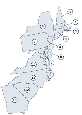
Write the name for every numbered outline. Outlines show modern states, not historical colony borders.
- ________________________________
- ________________________________
- ________________________________
- ________________________________
- ________________________________
- ________________________________
- ________________________________
- ________________________________
- ________________________________
- ________________________________
- ________________________________
- ________________________________
- ________________________________
Modern state outlines are location aids, not historical colony boundaries. Colonial Massachusetts included what is now Maine. The regional grouping is four New England, four Middle and five Southern Colonies.
QUIZPEN · SEPARATE ANSWER KEY
Thirteen colony names: answer key
- New Hampshire — New England
- Massachusetts — New England
- Rhode Island — New England
- Connecticut — New England
- New York — Middle
- New Jersey — Middle
- Pennsylvania — Middle
- Delaware — Middle
- Maryland — Southern
- Virginia — Southern
- North Carolina — Southern
- South Carolina — Southern
- Georgia — Southern
Modern state outlines are location aids, not historical colony boundaries. Colonial Massachusetts included what is now Maine. The regional grouping is four New England, four Middle and five Southern Colonies.
Sources: https://www.loc.gov/classroom-materials/united-states-history-primary-source-timeline/colonial-settlement-1600-1763/
10 random questions per mixed round · 50 questions in the full bank below
Published by Quizpen · Explanations include linked supporting reading. See our source-checking process and review limits.
PRACTICE BY SKILL
Choose a focused round
Practice one part of this topic with every question in that skill. Focused practice is separate from ten-question mixed rounds.
Getting your round ready…
BEHIND THE ROUND
A little more about this quiz
Practice all 13 original colonies in one map round, then recall their names without answer choices. Learn them in three groups: four New England Colonies, four Middle Colonies, and five Southern Colonies. The complete reference table pairs each colony with its group and map-question number.
The maps highlight modern states with the colonies’ names. They are a name-and-location learning aid: historical colonial borders differed, and Massachusetts once included Maine. Use the numbered blank map for a written recall exercise, then check the separate answer key.
The 50-question bank combines the thirteen map questions with settlements, regional economies, government, and independence. Choose a focused history round to distinguish Jamestown from Plymouth or independence in 1776 from constitutional ratification. Explanations acknowledge Indigenous homelands and enslaved labor, with National Park Service and National Archives links for further reading.
LEARN THE PATTERN
Practice the 13 colony names, regions, and founding-era distinctions
Use the complete thirteen-map round for names and locations. Choose a separate history round when you want settlement stories, regional economies, or independence questions.
All 13 colonies and their map-question numbers
Use the conventional 4 + 4 + 5 regional groups. The question number points to the modern-state outline used as a name-and-location aid in this bank.
| Colony | Study region | Map question |
|---|---|---|
| New Hampshire | New England | 1 |
| Massachusetts | New England | 2 |
| Rhode Island | New England | 3 |
| Connecticut | New England | 4 |
| New York | Middle | 5 |
| New Jersey | Middle | 6 |
| Pennsylvania | Middle | 7 |
| Delaware | Middle | 8 |
| Maryland | Southern | 9 |
| Virginia | Southern | 10 |
| North Carolina | Southern | 11 |
| South Carolina | Southern | 12 |
| Georgia | Southern | 13 |
These are the conventional three regional groups. The quiz uses modern state outlines to practice names and locations; historical colonial borders were different.
Reference sources: US Department of State: the three colonial regions · Maine Legislature: separation from Massachusetts
Check what you remember
Look away from the table. Try each question, then open it to check your answer.
Which region has five colonies? Name them.Show answer
The Southern Colonies: Maryland, Virginia, North Carolina, South Carolina, and Georgia.
Pennsylvania and Delaware belong to which group? Name its other two colonies.Show answer
The Middle Colonies. The other two are New York and New Jersey.
Why is Maine absent from the list of thirteen?Show answer
Maine was part of Massachusetts. It became a separate state in 1820.
Read modern outlines as a learning aid
The highlighted maps show modern states with the colonies’ names, not historical colonial boundaries. The conventional regions contain four New England, four Middle, and five Southern Colonies. Maine was part of Massachusetts before its separate statehood in 1820, so a historical question about the northernmost colony needs that context.
Recall all 13 colonies with the 4 + 4 + 5 check
Cover the colony column in the reference table and write one region at a time. These are the study groups used in this quiz:
- New England — New Hampshire, Massachusetts, Rhode Island, Connecticut: four names.
- Middle — New York, New Jersey, Pennsylvania, Delaware: four names.
- Southern — Maryland, Virginia, North Carolina, South Carolina, Georgia: five names.
Attach a place and date to a settlement
Keep Virginia–Jamestown–1607 separate from present-day Massachusetts–Plymouth–1620. The Virginia Company sponsored the Jamestown venture; Mayflower passengers signed the Mayflower Compact in 1620. Those are different organizations and agreements. These settlements were established on Indigenous homelands, not uninhabited land.
Use regions without treating them as identical communities
Recall the region’s full list before answering a comparison: New York, New Jersey, Pennsylvania, and Delaware make the Middle group. New England’s fishing and shipbuilding clues differ from Virginia’s tobacco questions, but a study grouping is not a claim that everyone in a region had the same work, beliefs, or experience.
Keep independence and constitutional ratification on separate dates
The Declaration of Independence belongs to 1776; Delaware’s first-state distinction concerns ratifying the Constitution in 1787. For a classroom or family round, combine a few map questions with selected history questions, then ask players to explain the date or role rather than repeat a surname. Use the worksheet’s numbered source links to check disputed answers.
What do the “original 13 colonies” mean here?
The phrase means the thirteen British colonies represented in the Declaration of Independence that became the first thirteen US states. It is not a count of all British colonies in North America, all European settlements, or the Indigenous nations already living there. When checking a historical document, allow for older names and spellings: the Declaration’s signatory headings include “Massachusetts Bay.”
Put it into practice
- Try a ten-question mixed round
- Try typed recall, maps and printable practice
- Identify all thirteen modern-state outlines
- Practice settlements and founders
- Review regions, economies, and government
- Separate independence and ratification events
- Build a thirteen-colonies worksheet
- Continue with the Bill of Rights
Further reading: US Department of State: the three colonial regions · Maine Legislature: separation from Massachusetts · NPS: Jamestown and Plymouth · National Archives: Declaration of Independence · National Archives: Constitution and ratification
QUESTIONS & ANSWERS
13 colonies quiz: the full question sheet
Identify the original 13 colonies, settlements, and regions. Play 10 of 50 questions with explanations, printable sheet, and answer key.
By Quizpen · Updated
Browse the full question bank50 questions & answers
Which original colony shares its name with the modern state highlighted on map 01.
 THE HIGHLIGHTED STATE

Modern state boundaries; not colonial borders. Reveal answer
New Hampshire. The highlighted modern state is New Hampshire (NH). New Hampshire lies between Vermont and Maine, north of Massachusetts. It widens toward the south and has a short Atlantic coast. These are modern state boundaries, not the colony’s historical extent.
Sources for this answer
Which original colony shares its name with the modern state highlighted on map 02.
 THE HIGHLIGHTED STATE

Modern state boundaries; not colonial borders. Reveal answer
Massachusetts. The highlighted modern state is Massachusetts (MA). Massachusetts lies south of Vermont and New Hampshire. Cape Cod curves outward from its southeastern coast, providing a useful recognition cue. These are modern state boundaries, not the colony’s historical extent.
Sources for this answer
Which original colony shares its name with the modern state highlighted on map 03.
 THE HIGHLIGHTED STATE

Modern state boundaries; not colonial borders. Reveal answer
Rhode Island. The highlighted modern state is Rhode Island (RI). Rhode Island lies east of Connecticut and south of Massachusetts. It is small enough that the enlarged outline is especially helpful. These are modern state boundaries, not the colony’s historical extent.
Sources for this answer
Which original colony shares its name with the modern state highlighted on map 04.
 THE HIGHLIGHTED STATE

Modern state boundaries; not colonial borders. Reveal answer
Connecticut. The highlighted modern state is Connecticut (CT). Connecticut lies below Massachusetts, with New York to the west and Rhode Island to the east. Its southern edge faces Long Island Sound. These are modern state boundaries, not the colony’s historical extent.
Sources for this answer
Which original colony shares its name with the modern state highlighted on map 05.
 THE HIGHLIGHTED STATE
Modern state boundaries; not colonial borders. Reveal answer
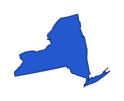
New York. The highlighted modern state is New York (NY). New York reaches from the Great Lakes toward the Atlantic. Long Island extends east from its southeastern corner, and New England lies to its east. These are modern state boundaries, not the colony’s historical extent.
Sources for this answer
Which original colony shares its name with the modern state highlighted on map 06.
 THE HIGHLIGHTED STATE

Modern state boundaries; not colonial borders. Reveal answer
New Jersey. The highlighted modern state is New Jersey (NJ). New Jersey is east of Pennsylvania and south of New York. Its Atlantic coastline and narrow middle give it a different outline from Delaware to the southwest. These are modern state boundaries, not the colony’s historical extent.
Sources for this answer
Which original colony shares its name with the modern state highlighted on map 07.
 THE HIGHLIGHTED STATE

Modern state boundaries; not colonial borders. Reveal answer
Pennsylvania. The highlighted modern state is Pennsylvania (PA). Pennsylvania lies below New York and west of New Jersey. A small northwestern projection reaches Lake Erie. These are modern state boundaries, not the colony’s historical extent.
Sources for this answer
Which original colony shares its name with the modern state highlighted on map 08.
 THE HIGHLIGHTED STATE

Modern state boundaries; not colonial borders. Reveal answer
Delaware. The highlighted modern state is Delaware (DE). Delaware is the small state east of Maryland and south of Pennsylvania. Its curved northern boundary helps distinguish it from the longer New Jersey across the Delaware River. These are modern state boundaries, not the colony’s historical extent.
Sources for this answer
Which original colony shares its name with the modern state highlighted on map 09.
 THE HIGHLIGHTED STATE

Modern state boundaries; not colonial borders. Reveal answer
Maryland. The highlighted modern state is Maryland (MD). Maryland wraps around the northern Chesapeake Bay and narrows sharply in the west. Delaware lies to its east and Pennsylvania to its north. These are modern state boundaries, not the colony’s historical extent.
Sources for this answer
Which original colony shares its name with the modern state highlighted on map 10.
 THE HIGHLIGHTED STATE
Modern state boundaries; not colonial borders. Reveal answer
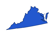
Virginia. The highlighted modern state is Virginia (VA). Virginia stretches from the Appalachians to the Atlantic, south of Maryland and West Virginia. Its eastern portion surrounds the southern Chesapeake Bay. These are modern state boundaries, not the colony’s historical extent.
Sources for this answer
Which original colony shares its name with the modern state highlighted on map 11.
 THE HIGHLIGHTED STATE
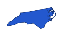
Modern state boundaries; not colonial borders. Reveal answer
North Carolina. The highlighted modern state is North Carolina (NC). North Carolina stretches east to west below Virginia. Its western mountains contrast with the long Atlantic coast on its eastern side. These are modern state boundaries, not the colony’s historical extent.
Sources for this answer
Which original colony shares its name with the modern state highlighted on map 12.
 THE HIGHLIGHTED STATE
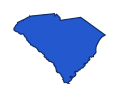
Modern state boundaries; not colonial borders. Reveal answer
South Carolina. The highlighted modern state is South Carolina (SC). South Carolina lies below North Carolina and east of Georgia. Its roughly triangular outline widens along the Atlantic coast. These are modern state boundaries, not the colony’s historical extent.
Sources for this answer
Which original colony shares its name with the modern state highlighted on map 13.
 THE HIGHLIGHTED STATE
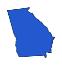
Modern state boundaries; not colonial borders. Reveal answer
Georgia. The highlighted modern state is Georgia (GA). Georgia is directly north of Florida, between Alabama and the Atlantic coast. Its eastern neighbor along much of that side is South Carolina. These are modern state boundaries, not the colony’s historical extent.
Sources for this answer
Which ocean bordered the thirteen colonies on the east?
Reveal answer
Atlantic Ocean. The colonies lay along the Atlantic coast of North America. Their inland claims varied, so the modern state outlines in this quiz are only location aids.
Sources for this answer
Which settlement in Virginia was founded in 1607?
Reveal answer
Jamestown. Jamestown was founded in Virginia in 1607, thirteen years before Plymouth. The Virginia Company organized the venture with commercial aims.
Sources for this answer
Which company organized the Jamestown venture?
Reveal answer
Virginia Company. The Virginia Company of London financed Jamestown as a commercial venture. Plymouth’s settlers had different religious and community motives.
Sources for this answer
Which ship carried the Pilgrims to New England in 1620?
Reveal answer
Mayflower. The Mayflower arrived in 1620 with the settlers associated with Plymouth. Jamestown’s earlier expedition used the Susan Constant, Godspeed, and Discovery.
Sources for this answer
In which present-day state was Plymouth Colony established?
Reveal answer
Massachusetts. Plymouth was established in present-day Massachusetts in 1620. It began as a separate colony and was later incorporated into Massachusetts.
Sources for this answer
What agreement did male Mayflower passengers sign in 1620 to organize their government?
Reveal answer
Mayflower Compact. The Mayflower Compact was an agreement to form a civil body politic and enact laws for the colony.
Sources for this answer
Which colony was founded last among the original thirteen?
Reveal answer
Georgia. The colony of Georgia was established in 1733, after the other twelve. Its southern position also made it a buffer between British and Spanish colonial territory.
Sources for this answer
Who is closely associated with founding Georgia in 1733?
Reveal answer
James Oglethorpe. Oglethorpe led the settlers who established Savannah in 1733. William Penn is associated with Pennsylvania, while Roger Williams is associated with Providence.
Sources for this answer
Which city was established as the first settlement of the British Georgia colony in 1733?
Reveal answer
Savannah. Savannah was the initial settlement of the British Georgia colony in 1733. Calling it Georgia’s first settlement without that qualification would ignore earlier Indigenous and European settlements.
Sources for this answer
Which founder is closely associated with Pennsylvania?
Reveal answer
William Penn. Penn received Pennsylvania’s charter in 1681 and arrived the next year. Philadelphia became the planned principal city of his colony.
Sources for this answer
William Penn belonged to which religious community?
Reveal answer
Quakers. Penn belonged to the Society of Friends, commonly called Quakers. His colonial plans attracted Quakers and other settlers seeking religious freedom.
Sources for this answer
Which city did William Penn establish as Pennsylvania’s principal city?
Reveal answer
Philadelphia. Philadelphia was laid out under Penn in 1682 with a street grid. Harrisburg is the state capital today, but was not Penn’s principal colonial city.
Sources for this answer
Who founded Providence in 1636?
Reveal answer
Roger Williams. Williams founded Providence in 1636 after his banishment from Massachusetts Bay. Providence later became part of the colony of Rhode Island.
Sources for this answer
Were the lands occupied by the thirteen colonies already home to Indigenous peoples?
Reveal answer
Yes, to many distinct Indigenous nations. The colonies were established on Indigenous homelands. Colonization involved trade, alliances, conflict, displacement, and dispossession of many different nations.
Sources for this answer
Which colony was associated with the Calvert family and Lord Baltimore?
Reveal answer
Maryland. Maryland was a proprietary colony associated with the Calverts, whose title was Lord Baltimore. The title should not be confused with the later city of Baltimore.
Sources for this answer
Which English colony centered on the former Dutch settlement of New Amsterdam after the takeover of 1664?
Reveal answer
New York. New Netherland included territory beyond today’s New York state. Its English takeover in 1664 brought the name New York to the central colony and city.
Sources for this answer
What was New York City called under Dutch rule?
Reveal answer
New Amsterdam. New Amsterdam was the Dutch settlement on Manhattan. The name changed to New York in 1664 when the English took control.
Sources for this answer
Which river became a major trade route through colonial New York?
Reveal answer
Hudson River. The Hudson offered a route inland from New York’s harbor. Its location helps explain the importance of trade in the Dutch and later English colony.
Sources for this answer
Which colonial region included Massachusetts, Connecticut, Rhode Island, and New Hampshire?
Reveal answer
New England. These four colonies form the conventional New England grouping. Maine belonged to Massachusetts, and Vermont was not a separate member of the original thirteen.
Sources for this answer
Which set lists only Middle Colonies?
Reveal answer
New York, New Jersey, Pennsylvania, Delaware. The Middle Colonies lay between New England and the Southern Colonies. Their four names are New York, New Jersey, Pennsylvania, and Delaware.
Sources for this answer
Which colony was the northernmost of the thirteen when counting Massachusetts’s then-territory of Maine?
Reveal answer
Massachusetts. Maine was part of Massachusetts until statehood in 1820, making colonial Massachusetts extend farthest north.
Sources for this answer
Which colony was farthest south?
Reveal answer
Georgia. Georgia was the southernmost of the thirteen. Florida lay farther south, but was not one of the thirteen colonies that declared independence in 1776.
Sources for this answer
Which present-day state was NOT one of the original thirteen colonies?
Reveal answer
Vermont. Vermont was not a separate member of the thirteen colonies and became the fourteenth state in 1791.
Sources for this answer
Which crop became especially important to Virginia’s colonial economy?
Reveal answer
Tobacco. Tobacco became Virginia’s major export crop. Its labor demands helped drive the growth of plantation agriculture and coercive labor systems.
Sources for this answer
Which labor system forced millions of Africans and their descendants to work in the colonies and later United States?
Reveal answer
Chattel slavery. Enslaved people were treated as property under chattel slavery; their forced labor was central to many colonial economies.
Sources for this answer
Which colonial region was especially associated with shipbuilding and Atlantic fishing?
Reveal answer
New England. New England’s harbors and forests supported maritime work, including shipbuilding and fishing. Farming also existed, but these activities distinguished the region’s economy.
Sources for this answer
Which colonies were often associated with growing grain such as wheat?
Reveal answer
Middle Colonies. The Middle Colonies produced grain such as wheat. Their breadbasket nickname describes a regional economic pattern, not a claim that other colonies grew no grain.
Sources for this answer
Which colony hosted the first representative legislative assembly in English North America in 1619?
Reveal answer
Virginia. Virginia’s assembly met in Jamestown in 1619. It represented a limited colonial electorate, not universal political participation for everyone living there.
Sources for this answer
Which river gave the Jamestown settlement access to the Chesapeake Bay?
Reveal answer
James River. Jamestown stood beside the James River, which leads into Chesapeake Bay. Its location offered a water route to the Atlantic trading network.
Sources for this answer
Which city hosted the Second Continental Congress when it adopted the Declaration of Independence?
Reveal answer
Philadelphia. Congress adopted the Declaration in Philadelphia in 1776. The Constitution was debated there later, in 1787, during a different convention.
Sources for this answer
In which year did the thirteen colonies adopt the Declaration of Independence?
Reveal answer
1776. Congress adopted the Declaration on July 4, 1776. Adoption, signing, and winning the Revolutionary War were separate steps with different dates.
Sources for this answer
Which king ruled Great Britain when the colonies declared independence?
Reveal answer
George III. George III reigned during the American Revolution. The Declaration directs many of its grievances at the British king, although Parliament also shaped colonial policy.
Sources for this answer
What was the main political objection captured by “no taxation without representation”?
Reveal answer
Parliament taxed colonists who elected no members to it. The slogan challenged Parliament’s taxation of colonists without their own elected representation in Parliament.
Sources for this answer
Which 1773 protest involved destroying tea in Boston Harbor?
Reveal answer
Boston Tea Party. Protesters destroyed tea in Boston Harbor in December 1773. The protest preceded the Declaration of Independence by more than two years.
Sources for this answer
Which colony contained Boston?
Reveal answer
Massachusetts. Boston was in Massachusetts, one of the New England colonies. Philadelphia, the city where the Declaration was adopted, was in Pennsylvania.
Sources for this answer
Which English settlement disappeared before the thirteen colonies took shape, becoming known as the Lost Colony?
Reveal answer
Roanoke. The fate of the late-sixteenth-century Roanoke settlers remains uncertain. Roanoke preceded the enduring colonies.
Sources for this answer
Which colony became the first state to ratify the US Constitution in 1787?
Reveal answer
Delaware. Delaware ratified the Constitution on December 7, 1787. First State refers to that ratification order, not to which colony was founded earliest.
Sources for this answer
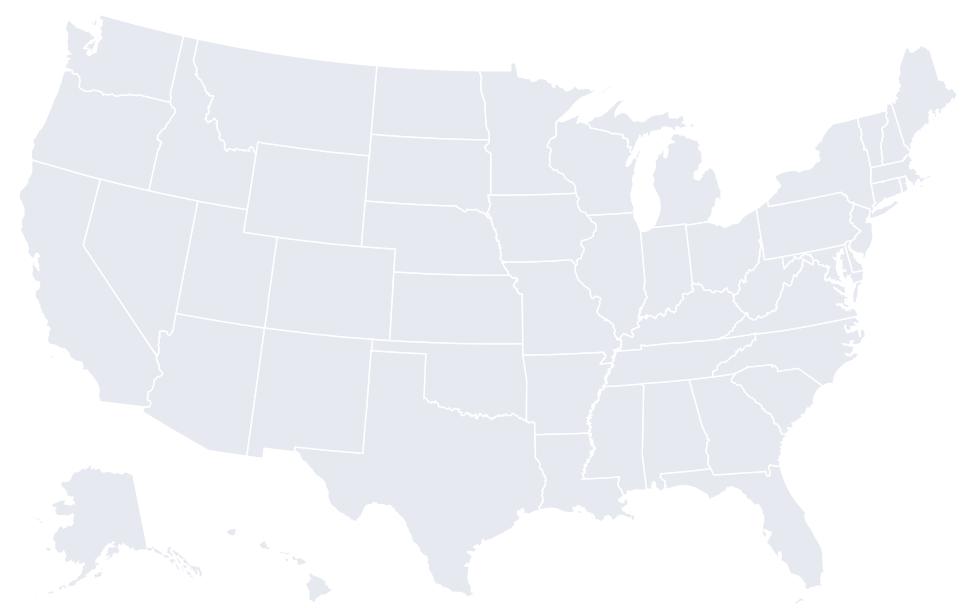
Answer key
- New Hampshire. The highlighted modern state is New Hampshire (NH). New Hampshire lies between Vermont and Maine, north of Massachusetts. It widens toward the south and has a short Atlantic coast. These are modern state boundaries, not the colony’s historical extent.
- Massachusetts. The highlighted modern state is Massachusetts (MA). Massachusetts lies south of Vermont and New Hampshire. Cape Cod curves outward from its southeastern coast, providing a useful recognition cue. These are modern state boundaries, not the colony’s historical extent.
- Rhode Island. The highlighted modern state is Rhode Island (RI). Rhode Island lies east of Connecticut and south of Massachusetts. It is small enough that the enlarged outline is especially helpful. These are modern state boundaries, not the colony’s historical extent.
- Connecticut. The highlighted modern state is Connecticut (CT). Connecticut lies below Massachusetts, with New York to the west and Rhode Island to the east. Its southern edge faces Long Island Sound. These are modern state boundaries, not the colony’s historical extent.
- New York. The highlighted modern state is New York (NY). New York reaches from the Great Lakes toward the Atlantic. Long Island extends east from its southeastern corner, and New England lies to its east. These are modern state boundaries, not the colony’s historical extent.
- New Jersey. The highlighted modern state is New Jersey (NJ). New Jersey is east of Pennsylvania and south of New York. Its Atlantic coastline and narrow middle give it a different outline from Delaware to the southwest. These are modern state boundaries, not the colony’s historical extent.
- Pennsylvania. The highlighted modern state is Pennsylvania (PA). Pennsylvania lies below New York and west of New Jersey. A small northwestern projection reaches Lake Erie. These are modern state boundaries, not the colony’s historical extent.
- Delaware. The highlighted modern state is Delaware (DE). Delaware is the small state east of Maryland and south of Pennsylvania. Its curved northern boundary helps distinguish it from the longer New Jersey across the Delaware River. These are modern state boundaries, not the colony’s historical extent.
- Maryland. The highlighted modern state is Maryland (MD). Maryland wraps around the northern Chesapeake Bay and narrows sharply in the west. Delaware lies to its east and Pennsylvania to its north. These are modern state boundaries, not the colony’s historical extent.
- Virginia. The highlighted modern state is Virginia (VA). Virginia stretches from the Appalachians to the Atlantic, south of Maryland and West Virginia. Its eastern portion surrounds the southern Chesapeake Bay. These are modern state boundaries, not the colony’s historical extent.
- North Carolina. The highlighted modern state is North Carolina (NC). North Carolina stretches east to west below Virginia. Its western mountains contrast with the long Atlantic coast on its eastern side. These are modern state boundaries, not the colony’s historical extent.
- South Carolina. The highlighted modern state is South Carolina (SC). South Carolina lies below North Carolina and east of Georgia. Its roughly triangular outline widens along the Atlantic coast. These are modern state boundaries, not the colony’s historical extent.
- Georgia. The highlighted modern state is Georgia (GA). Georgia is directly north of Florida, between Alabama and the Atlantic coast. Its eastern neighbor along much of that side is South Carolina. These are modern state boundaries, not the colony’s historical extent.
- Atlantic Ocean. The colonies lay along the Atlantic coast of North America. Their inland claims varied, so the modern state outlines in this quiz are only location aids.
- Jamestown. Jamestown was founded in Virginia in 1607, thirteen years before Plymouth. The Virginia Company organized the venture with commercial aims.
- Virginia Company. The Virginia Company of London financed Jamestown as a commercial venture. Plymouth’s settlers had different religious and community motives.
- Mayflower. The Mayflower arrived in 1620 with the settlers associated with Plymouth. Jamestown’s earlier expedition used the Susan Constant, Godspeed, and Discovery.
- Massachusetts. Plymouth was established in present-day Massachusetts in 1620. It began as a separate colony and was later incorporated into Massachusetts.
- Mayflower Compact. The Mayflower Compact was an agreement to form a civil body politic and enact laws for the colony.
- Georgia. The colony of Georgia was established in 1733, after the other twelve. Its southern position also made it a buffer between British and Spanish colonial territory.
- James Oglethorpe. Oglethorpe led the settlers who established Savannah in 1733. William Penn is associated with Pennsylvania, while Roger Williams is associated with Providence.
- Savannah. Savannah was the initial settlement of the British Georgia colony in 1733. Calling it Georgia’s first settlement without that qualification would ignore earlier Indigenous and European settlements.
- William Penn. Penn received Pennsylvania’s charter in 1681 and arrived the next year. Philadelphia became the planned principal city of his colony.
- Quakers. Penn belonged to the Society of Friends, commonly called Quakers. His colonial plans attracted Quakers and other settlers seeking religious freedom.
- Philadelphia. Philadelphia was laid out under Penn in 1682 with a street grid. Harrisburg is the state capital today, but was not Penn’s principal colonial city.
- Roger Williams. Williams founded Providence in 1636 after his banishment from Massachusetts Bay. Providence later became part of the colony of Rhode Island.
- Yes, to many distinct Indigenous nations. The colonies were established on Indigenous homelands. Colonization involved trade, alliances, conflict, displacement, and dispossession of many different nations.
- Maryland. Maryland was a proprietary colony associated with the Calverts, whose title was Lord Baltimore. The title should not be confused with the later city of Baltimore.
- New York. New Netherland included territory beyond today’s New York state. Its English takeover in 1664 brought the name New York to the central colony and city.
- New Amsterdam. New Amsterdam was the Dutch settlement on Manhattan. The name changed to New York in 1664 when the English took control.
- Hudson River. The Hudson offered a route inland from New York’s harbor. Its location helps explain the importance of trade in the Dutch and later English colony.
- New England. These four colonies form the conventional New England grouping. Maine belonged to Massachusetts, and Vermont was not a separate member of the original thirteen.
- New York, New Jersey, Pennsylvania, Delaware. The Middle Colonies lay between New England and the Southern Colonies. Their four names are New York, New Jersey, Pennsylvania, and Delaware.
- Massachusetts. Maine was part of Massachusetts until statehood in 1820, making colonial Massachusetts extend farthest north.
- Georgia. Georgia was the southernmost of the thirteen. Florida lay farther south, but was not one of the thirteen colonies that declared independence in 1776.
- Vermont. Vermont was not a separate member of the thirteen colonies and became the fourteenth state in 1791.
- Tobacco. Tobacco became Virginia’s major export crop. Its labor demands helped drive the growth of plantation agriculture and coercive labor systems.
- Chattel slavery. Enslaved people were treated as property under chattel slavery; their forced labor was central to many colonial economies.
- New England. New England’s harbors and forests supported maritime work, including shipbuilding and fishing. Farming also existed, but these activities distinguished the region’s economy.
- Middle Colonies. The Middle Colonies produced grain such as wheat. Their breadbasket nickname describes a regional economic pattern, not a claim that other colonies grew no grain.
- Virginia. Virginia’s assembly met in Jamestown in 1619. It represented a limited colonial electorate, not universal political participation for everyone living there.
- James River. Jamestown stood beside the James River, which leads into Chesapeake Bay. Its location offered a water route to the Atlantic trading network.
- Philadelphia. Congress adopted the Declaration in Philadelphia in 1776. The Constitution was debated there later, in 1787, during a different convention.
- 1776. Congress adopted the Declaration on July 4, 1776. Adoption, signing, and winning the Revolutionary War were separate steps with different dates.
- George III. George III reigned during the American Revolution. The Declaration directs many of its grievances at the British king, although Parliament also shaped colonial policy.
- Parliament taxed colonists who elected no members to it. The slogan challenged Parliament’s taxation of colonists without their own elected representation in Parliament.
- Boston Tea Party. Protesters destroyed tea in Boston Harbor in December 1773. The protest preceded the Declaration of Independence by more than two years.
- Massachusetts. Boston was in Massachusetts, one of the New England colonies. Philadelphia, the city where the Declaration was adopted, was in Pennsylvania.
- Roanoke. The fate of the late-sixteenth-century Roanoke settlers remains uncertain. Roanoke preceded the enduring colonies.
- Delaware. Delaware ratified the Constitution on December 7, 1787. First State refers to that ratification order, not to which colony was founded earliest.